
Alberta: Athabasca Glacier Forefield: A World Revealed Under The Ice
1) Introduction: A Melting Story
Have you ever wondered what Canada looked like at the end of the last ice age? What geological landforms were created by glaciers during the last ice age? There is a place in Canada where you get a glimpse into answers to these questions. It is the Athabasca Glacier (Photo 1), located in the Canadian Rocky Mountains. The Athabasca Glacier occurs in Jasper National Park, close to the Icefields Parkway, between the cities of Banff and Jasper, Alberta, Canada (Photo 2).

Photo 1: Athabasca Glacier located in the Canadian Rocky Mountains, close to the Icefields Parkway, in Jasper National Park, Alberta, Canada. Photo composed by Andy Fyon, August 5, 2019.
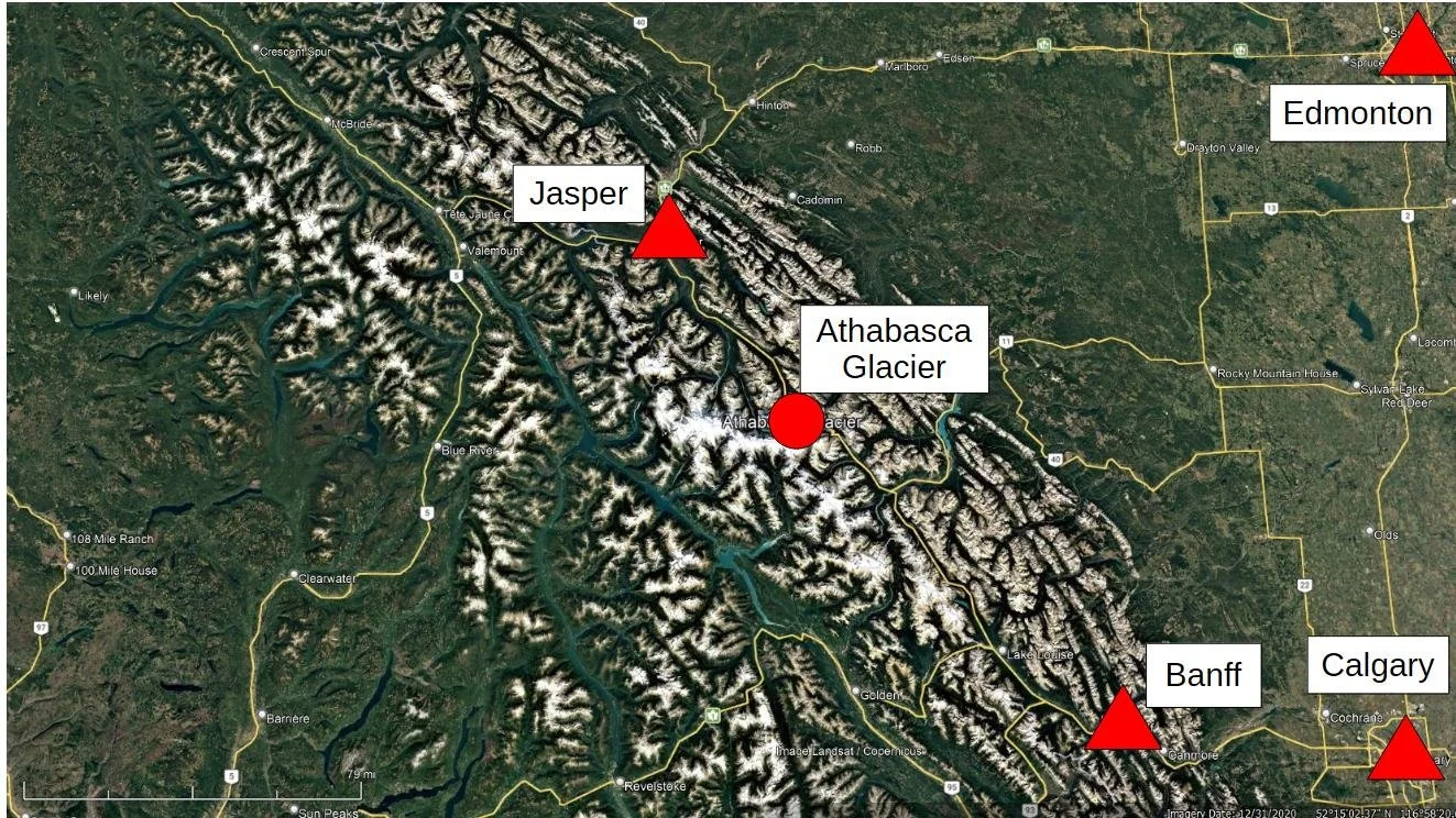
Photo 2: Location of the Athabasca Glacier, nestled between the towns of Jasper and Banff, in the Rocky Mountains, Alberta, Canada. Satellite image from Google Earth, 2022.
The Athabasca Glacier is one of several glaciers that flow – that’s right, the ice flows – from its source in the Columbia Icefield (Photo 3). The Columbia Icefield is the largest icefield in the Canadian Rockies. It is a remnant of an ice sheet that covered most of Western Canada's mountains. The Athabasca Glacier flows down a valley, between the mountains, towards the Icefields Parkway Highway and the Columbia Icefields Discovery Centre (Photo 3), a popular tourist destination.
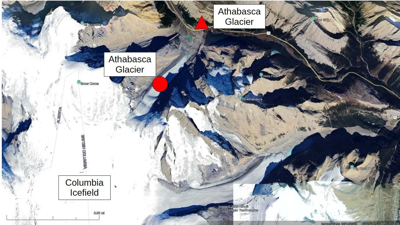
Photo 3: Detailed satellite image showing the Athabasca Glacier that extends down the valley from its source in the Columbia Icefield. Satellite image from Google Earth, 2022.
The Athabasca Glacier is an important and popular tourist destination because:
it is accessible to most tourists who may otherwise never see, let alone stand on, a glacier;
deglaciation is creating an unusual and barren landscape that resembles, in a general way, what much of Canada looked like at the end of the last ice age;
tourists see geological features that formed during the growth and retreat of the glacier;
tourists see the impact of a warming climate, which has caused the Athabasca Glacier to melt down and back for the last 182 years (1844 peak extent to 2026).
Join me in this note as I briefly describe the recent ice age that affected Canada and some of the geological features created during that ice age.
1a) Land acknowledgement
I acknowledge that the Athabasca Glacier lies in the homelands of several First Nations in Treaty 6 area (signed in 1876) and the Métis people. This area includes parts of the First Nations homelands of the Cree and Blackfoot peoples. I appreciate that recognizing First Nations people using Treaty areas is not a good way of doing this, but I have no other option because I do not have access to a map showing traditional homelands. For that I apologize. I recognize the First Nations and Métis people as stewards of this land for many years. Acknowledging these peoples and their land stewardship reminds us to reflect on and respect their unique relationship with this land. My acknowledgment is also an invitation for all of us to identify and engage in actions that respect and reinforce our commitments to Indigenous rights made in Treaty 6, Section 35 of the Constitution Act, 1982, and the recommendations of the Truth and Reconciliation Commission of Canada Calls to Action report. As settlers, we are Treaty people.
1b) Disclaimer
I am a geologist. I see the world through “geological eyes.” I have not formally mapped or studied the land in front of the Athabasca Glacier. That said, I will share some anecdotal observations about the geology of the area. My observations are neither systematic nor rigorous. They should not be used in any scientific way. I make some generalizations to provide information to a non-geological audience. Generalizations may be inappropriate, incorrect or misleading, so please consider this note to be merely my subjective musings, supported by observations that are not of research quality.
1c) The intent of this note
I visited the Athabasca Glacier during the summers of 1993, 2007, 2011, 2014, 2019, and 2023. As a geologist, I am drawn to this remarkable area to observe geological features that were created during and following the glaciation and the progressive deglaciation of the area as the glacier melts back towards its source. In this note, I describe some of those geological features. This transformation from ice-covered land to barren land generally shows what Canada looked like at the end of the last ice age, a few thousand years ago. My observations will help enrich your experience, should you visit the Athabasca Glacier.
In a companion note, I describe some specialized plants that have recolonized the subalpine, deglaciated land since 1844.
1d) People, ice, wind, and dawn magic
Between 9 a.m. and 5 p.m. the Columbia Icefields Discovery Centre is a very busy place. The parking lot is full. The interpretation displays are busy. The restaurant and cafeteria are packed. People are everywhere. But, after 5 p.m., most of the people leave for the towns of Jasper or Banff, or farther afield. The parking lot empties, except for the RVers who pay to stay overnight. Highway traffic reduces to an occasional vehicle. The evening’s golden-hour sunlight illuminates the mountain peaks and the ice (Photo 4).

Photo 4: Evening light on the snow-covered Mt. Andromeda, just to the south of the Athabasca Glacier. Photo composed by Andy Fyon, August 5, 2019.
If you walk over the barren, ice-free land towards the front of the glacier, you experience the quiet, but icy, chill of the wind that blows off the glacier. This is the katabatic wind created when cold, dense air flows off the Columbia Icefield, along the surface of the Athabasca Glacier towards the valley floor. It is invigorating.
1e) Rivers of ice: the Columbia Icefield and its outlet glaciers
While looking west from the veranda of Columbia Icefields Discovery Centre, from about 1,975m (6,480ft) above sea level, you see the iconic Athabasca Glacier across the Icefields Parkway. The Athabasca Glacier is the highlight that attracts so many tourists (Photo 5). Like a white ribbon, it extends about 6km (3.8mi) down the valley between the mountains. The glacier is up to 320m thick (1,059ft) in places. Its elevation at the top end, where it leaves the Columbia Icefield, is 2,800m (9,186ft) and 1,980m (6,495ft) at the front or bottom end. It covers an area of about 7km square (2.7mi square). At its steepest area, the glacier flows at a speed of about 127m (415ft) per year. Near the bottom, the glacier flows at an average rate of about 15m (50ft) per year. But that downward flow is not to be mistaken for its rate of melting, also known as retreat, which is about 10 to 15m (32 to 50ft) per year. Retreats up to 25m (80ft) annually have been recorded. The retreat is the distance between one summer’s ice front and the next, which means that, despite the slow continual feed of ice flowing down the valley, the glacier is actually melting back more quickly than it is advancing.
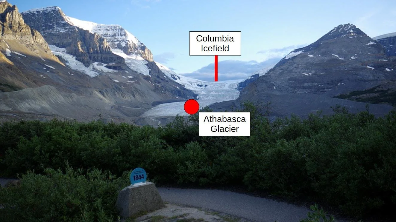
Photo 5: The Athabasca Glacier is one of several outlet glaciers that flow out of the Columbia Icefield, down a valley between mountains. Photo by Andy Fyon, August 5, 2019.
If you follow the Athabasca Glacier up to its top, you see the white Columbia Icefield, which lies like a horizontal layer of cake icing on a plateau (Photo 5). This is the source of the Athabasca Glacier. The Columbia Icefield is the largest icefield in North America's Rocky Mountains. The icefield covers 215km² (83mi²). It is the birthplace of six large outlet glaciers: Athabasca; Castleguard; Columbia; Dome; Stutfield; and Saskatchewan. These are called outlet glaciers because they flow from the Columbia Icefield through valley gaps in the surrounding mountains. The ice that composes the Columbia Icefield is between 238,000 to 126,000 years old. You might think old ice lives forever, but you would be wrong. The Columbia Icefield and its associated glaciers are melting rapidly due to a changing climate.
1f) From ice to land: the Athabasca Glacier's retreating story
Markers occur along the trail to the Athabasca Glacier (Photo 6) show the date and location where the front of the glacier sat as far back as 1844. The markers serve as clocks that tell us the year the land became free of ice as the glacier melted back.

Photo 6: Grandson Brayden stands beside the blue marker, which tells the date, 1992, when the toe of the Athabasca Glacier sat at this location. Brayden’s father stood on the Athabasca Glacier almost 30 years before. Notice how far back the glacier has receded over three decades! Photo composed by Andy Fyon, August 8, 2023.
When a glacier melts, it does not simply disappear. It reveals a new and recovering deglaciated landscape that was entombed beneath hundreds of metres of ice for thousands of years. The deglaciated land may look nondescript, but it is a complex pattern of ground-up rock, scattered boulders, two rivers, a lake, and ridges that have emerged from beneath the ice. These land features were created over millennia beneath, beside, and in front of the Athabasca Glacier. Each represents a page of a remarkable geological story that was repeated across almost all of Canada during the last ice age, which ended about 15,000 years ago.
2) Ice Ages and a Changing Climate
An ice age is defined as a period of time, lasting millions of years, when the climate was cold. During an ice age, shorter glacial (cold) and interglacial (warm) cycles occur. Over Earth’s 4,500,000,000-year history the climate changed many times and there have been at least five major ice ages. At times, the Earth existed in an ice house state, when a cold climate transformed its surface into an icy blanket. There were times when the Earth existed in a hothouse state, when a warm climate melted all the ice sheets, even those that existed at the north and south poles.
2a) The time when almost all of Canada was ice covered
The most recent ice age, called the Quaternary Ice Age, began about 2,588,000 years ago. Technically, we are still in that ice age because ice sheets cover parts of the Arctic and Antarctic poles. During the Quaternary glaciation, parts of the Earth’s surface experienced a series of alternating, cold, glacial events and warmer, interglacial events, when ice melted. The most recent glacial period during the Quaternary Ice Age is called the Wisconsin glaciation, which began approximately 75,000 years ago and lasted until about 11,700 years ago. The end of the Wisconsin glaciation is called the Younger Dryas. During the Younger Dryas, which began about 12,800 years ago and ended about 11,700 years ago, glaciers around the world, including the Athabasca Glacier, grew in response to the brief cold period. That brief period was followed by a warmer climate and melting of the ice sheets, except for those at the north and south poles.
About 25,000 to 21,000 years ago, the ice sheets associated with the Wisconsin glaciation reached their maximum coverage across Canada and northern United States. At that time, almost all of Canada was covered by ice sheets except for three areas, which remained ice free:
an area in the Yukon, Alaska and Siberia called Beringia;
a small area on the west coast of Vancouver Island called Topknot Lake; and
parts of the Brooks Peninsula, Vancouver Island.
2b) Holocene time and human civilization
The time period that followed the end of the Wisconsin glaciation, at the end of the Younger Dryas, is called the Holocene epoch. It is the most recent period of Earth's history and the time period we live in today. The Holocene epoch is characterized by a warm, stable climate. That warm climate is considered the catalyst for the development of human civilization.
3) Canada after the ice
Today, most of Canada’s land is no longer covered by an ice sheet. Instead, we see a vegetated landscape, except for relic alpine glaciers that remain in the Cordillera Mountains of Western Canada and relic ice caps that remain in parts of the High Arctic.
On the deglaciated landscape, we see evidence of the earlier glaciation that shaped Canada’s land surface. The ice sheets carved and removed vast quantities of the rock. They sculpted valleys and left depressions in the rock. Unconsolidated sedimentary material, called glacial till, was deposited beneath the ice sheets. Melting ice sheets generated enormous volumes of meltwater that fed rivers and filled land depressions to create the thousands of lakes we see today. These meltwater rivers deposited sediments consisting of clay, silt, sand and gravel across the land.
4) Recent melting of the Athabasca Glacier
Melting of a glacier can take place quickly in geological time. For example, the Athabasca Glacier retreats about 10 to 15m (32 to 50 ft) per year, based on the ice lost over the past 125 years. But, the ice history of the Athabasca Glacier is complicated and the early parts of that history are lost in time because they were mostly destroyed by the advances and retreats of the glacier.
In 1844, when the Northern Hemisphere experienced a cooling period called the Little Ice Age, the Athabasca Glacier grew to a length of 8km (5mi). It reached all the way to the present location of the Columbia Icefields Discovery Centre (Photo 7). But, today, the glacier is only about 6km (3.7mi) long, nearly 2 km shorter than it was at its peak in 1844 - clear evidence that the glacier is melting back in response to a warming climate.

Photo 7: This historic photo shows the maximum extent of the Athabasca Glacier in 1844. The glacier extended to the location of the Columbia Icefields Discovery Centre. Photo on display in the Columbia Icefields Discovery Centre, August 5, 2019.
There are several ways to estimate the average rate at which the Athabasca Glacier is melting and retreating. The glacier’s terminal moraine, the line of farthest advance down the valley, was created in 1844 or (182 years ago as of 2026). Using a Google Earth satellite image composed in 2022, scientists determined that the toe of the glacier was located up the valley about 1,900m (1.2mi or 6,225ft) away from the line of farthest advance. That translates to an average retreat rate of 10m (34ft) per year, between 1843 and 2022. This is consistent with other estimates of the average retreat rate, which range from 5m (16ft) to 25m (82ft) annually.
The Athabasca Glacier is also melting down or thinning. In some places, the glacier thinned by as much as 100m (328ft). In 2023, the surface of the glacier melted down nearly 9m (30ft) vertically in just one year, which is a new vertical, or deflation, melt rate record.
As the Athabasca Glacier retreats up the valley, it exposes land in front of the glacier that it once covered.
5) Geological Features
In this section, I describe some geological features that formed beneath, adjacent to, and in front of the Athabasca Glacier, during and after glaciation. Note that alternative interpretations are possible for some of the geological features I describe, subject to additional scrutiny in the field.
5a) Mountain rocks and glacial till
The most obvious large, non-ice geological features are the mountains. The mountains that flank the Athabasca Glacier (Photo 5) are made up primarily of limestone and dolostone rock. Limestone consists of calcium carbonate (CaCO3), known as the mineral calcite. Dolostone consists of calcium magnesium carbonate (CaMg(CO3)2). As the Athabasca Glacier flows through the mountains and down the valley, it grinds up the rocks into very small particles called rock flour. The carbonate-rich rock flour is deposited beneath the glacier as a deposit type called glacial till. Because of its lime-rich geochemical composition, the exposed glacial till constitutes a calcareous habitat. In a companion note, I discuss how the calcareous habitat supports specialized calcicolous plant species, which tolerate and even thrive in this carbonate-rich habitat.
5b) Valley glacier
The Athabasca Glacier originates from the Columbia Icefield and flows down the valley toward the Columbia Icefields Discovery Centre. For that reason, the Athabasca Glacier is called an outlet valley glacier (Photo 5). Valley glaciers are generally long tongues of ice that flow down a valley (Sandford, 2016).
5c) Glacial toe
The terminus, or front, of a glacier is called the toe of the glacier (Photo 8).
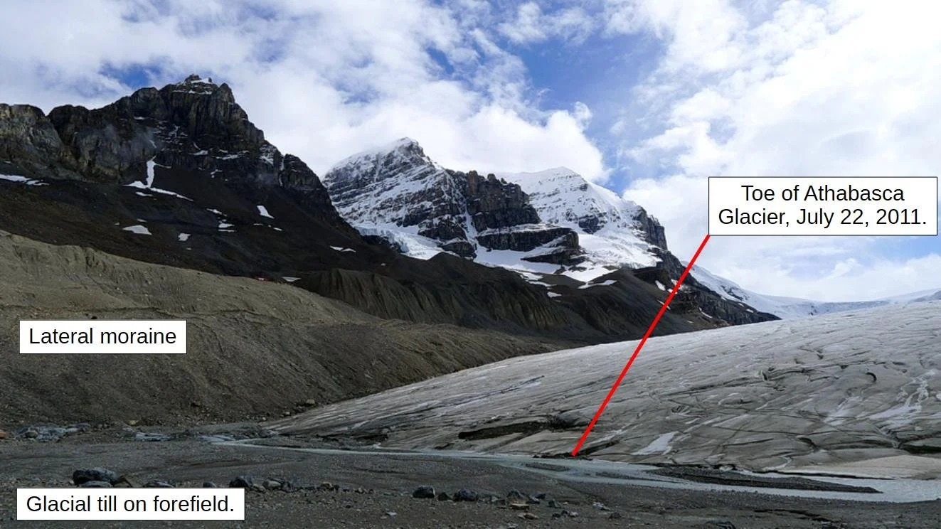
Photo 8: The toe of the glacier, at the end of the red line, marked the end of the Athabasca Glacier. The location of the toe moves down the valley when the glacier advances and moves up the valley when the glacier melts or retreats back. Photo composed by Andy Fyon, July 22, 2011.
5d) Ice-free forefield
The area between the current toe of a glacier and the moraine created by the latest glacial maximum is called the glacier forefield (Photo 9). The Athabasca Glacier reached its latest glacial maximum in 1844, during the Little Ice Age. Since that time, the glacier has been melting back and more forefield land has become free of ice.

Photo 9: The forefield is a barren rocky landscape that occurs in front of the Athabasca Glacier. The forefield is exposed as the glacier melts back. Photo composed by Andy Fyon, August 6, 2019.
5e) Terminal moraine
A terminal moraine marks the maximum advance of a glacier. The terminal moraine created by the Athabasca Glacier is a ridge located near the Columbia Icefields Discovery Centre (Photo 10; heavy red line). A lot of vegetation covers the terminal moraine (Photo 11); however, there are areas with less vegetation. Those areas reveal that the terminal moraine consists of glacial till and a chaotic mix of limestone cobbles, pebbles and rock flour (Photo 12). The terminal moraine marks the farthest advance down the valley by the Athabasca Glacier during the Little Ice Age in 1844. After the creation of the terminal moraine, the Athabasca Glacier has generally retreated or melted back towards its source in the Columbia Icefield, well above the valley.

Photo 10: Location of the terminal moraine (thick red line) that formed in 1844, lateral moraines (thick yellow lines), and seasonal push moraines (thin yellow lines) related to the Athabasca Glacier. Image is a Google Earth satellite image dated 2022.

Photo 11: The heavily vegetated 1844 terminal moraine located close to the Columbia Icefields Discovery Centre. Grandsons Adrien (red coat) and Brayden for scale. Photo composed by Andy Fyon, August 8, 2023.
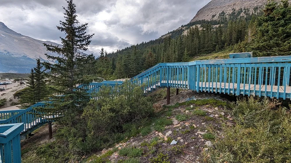
Photo 12: An exposed area of the 1844 terminal moraine located along the path to the Columbia Icefields Discovery Centre. The parking lot used by RVers to stay overnight is on the left. Photo by Andy Fyon, August 8, 2023.
5f) Seasonal push moraines
Several smaller ridges or moraines are preserved on the Athabasca Glacier forefield (thin red lines, Photo 10). The ridge crest of each generally trends across the forefield perpendicular to the valley that contains the Athabasca Glacier (Photo 13). These may mark the glacier’s seasonal movement, where the glacier’s toe rested at the end of a seasonal winter advance. In that regard, these ridges are more accurately called seasonal push moraines. Think of the glacier acting as a bulldozer that pushed forward older, loose, glacial sedimentary material deposits on the forefield.
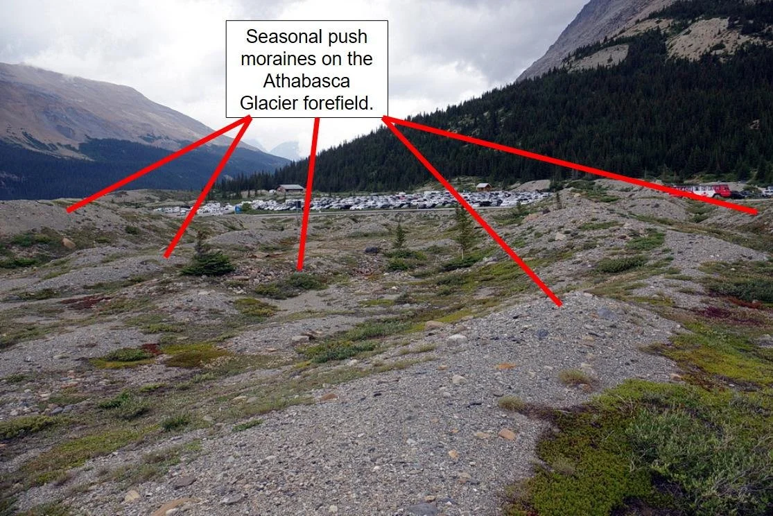
Photo 13: These ridges likely represent seasonal push moraines that developed at the toe of the glacier due to the winter advance of the Athabasca Glacier. Photo composed by Andy Fyon, August 8, 2023.
5g) Lateral moraine
Prominent rock debris ridges occur along the valley walls on both sides of the Athabasca glacier (thick yellow lines, Photo 10). These are called lateral moraines. They extend well beyond and above the present ice limits (Photo 14). The lateral moraines are accumulations of frost-shattered, angular, unsorted, unconsolidated rock fragments. This debris accumulated from material that avalanched from the valley walls onto the ice margins of the glacier and rock material plucked off the walls of the adjacent valley. The lateral moraine ridges formed as the glacier advanced and retreated, scraping and eroding the valley walls and pushing the debris to the sides of the glacier.

Photo 14: The lateral moraine along the south side of the Athabasca Glacier. The top of the lateral moraine and the glacier used to be about equal. That the top of the lateral moraine is much higher than the surface of the glacier illustrates that the glacier has melted down, or deflated. Photo composed by Andy Fyon, July 22, 2011.
The lateral moraines show the historic extent - the thickness and volume - of the Athabasca Glacier and the path followed by the glacier’s descent along the valley. For example, in places, the top of the south-eastern lateral moraine is estimated to be about 125m (410ft) above the valley floor, well above the present surface of the glacier. The height difference illustrates that the Athabasca Glacier has melted down, or deflated, at a rate of about 1m (3.2ft) per year, with recent downward melt events reaching up to 9m (30ft) per year.
Over time, some parts of the unstable lateral moraines collapsed onto the ice surface or onto the forefield exposing blue glacier ice that was buried by the lateral moraine (Photo 15).

Photo 15: Blue glacial ice that is buried at the base of the lateral moraine, along the north edge of the valley once filled by the Athabasca Glacier, Jasper National Park, Alberta, Canada. Photo composed by Andy Fyon, August 8, 2023.
5h) Medial moraine
A medial moraine forms where rock debris was scraped and broken off the valley wall rocks. The loose rock was carried along the junction between two adjacent, but separate, ice streams. If the two ice streams converge into a single ice stream, the debris merges into a single rocky debris ridge running down the middle of the combined glacier. Medial moraines are often recognized as a dark, debris-filled ridge on the glacier's surface. Medial moraines are reported on the Athabasca Glacier, but I did not recognize them during my visits.
5i) Ablation and hummocky moraines
The surface of a glacier may be covered by debris that avalanches off the valley walls onto the top of the exposed ice. When a block of debris-covered stagnant glacier ice melts, or ablates, the surface debris ends up on the valley floor, where it is called an ablation moraine. An ablation moraine may be identified by irregular mounds and depressions on the land’s surface, consisting of unsorted and angular rocks and sediment. You may encounter the term hummocky moraine that describes the land’s irregular surface, consisting of irregular mounds and depressions. Hummocky moraine is considered as a type of ablation moraine.
Ablation moraines are reported to associate with the Athabasca Glacier. To my eye, there are areas of the Athabasca Glacier forefield that have an irregular hummocky surface and consist of a chaotic mix of rock flour, pebbles, and cobbles (Photo 16). These hummocky areas may be ablation moraines.

Photo 16: Possible ablation moraine developed adjacent to a lateral moraine and the toe of the Athabasca Glacier. The shallow depressions, suggestive of hummocky land, and blocks of rock debris lying on the surface of the glacial till suggest some debris was deposited by ablation. However, proximity to the lateral moraine and meltwater channels complicate the interpretation. Photo by Andy Fyon, July 22, 2011.
5j) Proglacial meltwater river
Most glaciers have a seasonal river that flows from the margin or toe of a glacier. The water is derived from melting glacier ice and is called a proglacial meltwater river.
At least two proglacial rivers occur on the Athabasca Glacier forefield (Photos 17 and 18). Because the rivers derive their water from melting glaciers, the river water volume varies during the summer season and even during the day. Close to the Athabasca Glacier, the meltwater river carries a lot of suspended clay and silt material, which turns the river brown (Photo 17). Both rivers flow into Sunwapta Lake (Photo 18).

Photo 17: A meltwater river that drains from the toe of the Athabasca Glacier. The brown water is caused by suspended rock flour. Photo composed by Andy Fyon, August 8, 2023.

Photo 18: A second meltwater river that drains from glaciers located on Mt. Athabasca, located to the south of the Athabasca Glacier, also drains into Sunwapta Lake. Photo by Andy Fyon, composed from Wilcox Pass trail, August 6, 2019.
5k) Proglacial Sunwapta Lake
The shallow 6m (20ft) Sunwapta Lake (Photo 19) is a proglacial lake that formed on the forefield land in front of the Athabasca Glacier. It is fed by two proglacial meltwater rivers. The lake occupies an ice-gouged rock basin that was eroded into less resistant rock. It began to form in 1938 when the glacier retreated to expose the basin. It reached its maximum size in 1966 and is now shrinking because it is being infilled by deltas of re-worked glacial debris.

Photo 19: Sunwapta Lake is a proglacial lake that has formed in a depression on the forefield of the Athabasca Glacier. Photo composed by Andy Fyon, from the moraines located at the parking lot, Columbia Icefields Discovery Centre. Photo by Andy Fyon, August 9, 2023.
The Sunwapta River flows northwards along the Sunwapta Valley where it joins the Athabasca River. The Athabasca River then flows about 1500 km northeast across Alberta, drains into Lake Athabasca then into the Slave River, and joins the Mackenzie River. The Mackenzie River flows into the Arctic Ocean near Tuktoyaktuk.
5l) Meltwater river delta
A river delta is a semi-circular to triangular- shaped landform that is created by the deposition of suspended rock flour carried by a meltwater river. The delta forms where the river enters a lake or slower-moving body of water, where the river no longer has the energy to carry the suspended material.
Two deltas have formed at the edge of Sunwapta Lake where two meltwater rivers merge with the lake and drop their suspended material (Photo 20). The delta material consists partly of reworked glacial till and partly of transported rock flour released by the melting glacier. Both Sunwapta Lake deltas have a roughly triangular shape with the apex pointed up river (Photo 21).
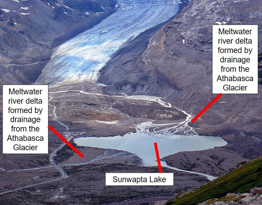
Photo 20: Two deltas, marked by the tip of the red lines, are forming at the edge of Sunwapta Lake where two meltwater rivers merge with the lake and drop their suspended material. The proglacial river on the left appears to drain from glaciers located on Mt. Athabasca, located to the south of the Athabasca Glacier, not from the Athabasca Glacier. View from the Wilcox Pass trail. Photo composed by Andy Fyon, Aug 6, 2019.

Photo 21: A delta developed where the meltwater river, derived by melting of the Athabasca Glacier, merged with proglacial Sunwapta Lake. The delta formed at the transition where the turbulent river water flow entered the calm water body of Sunwapta Lake. Photo composed by Andy Fyon, August 8, 2023.
5m) Glacial striations
Glacial striations or striae are scratches and gouges cut into the rock by glacial abrasion. The abrasive material that created the scratches consisted of rock fragments that were embedded in the base of the glacier. The striations consist of multiple, straight, parallel scratches. The direction of the striations may be used to determine the direction the glacier moved.
Glacial striations are visible on a large polished rock surface exposed along the trail to the Athabasca Glacier toe (Photo 22).

Photo 22: Rock striations were carved into this rock by abrasive rock fragments frozen into the base of the Athabasca Glacier. Photo composed by Andy Fyon, along the trail to the glacier, August 6, 2019.
6) Summary
The Athabasca Glacier, nestled in the Canadian Rockies along the Icefields Parkway, is a stunning, accessible natural attraction. It affords a glimpse into Canada’s recent geological past, when almost all of Canada was covered by several ice sheets during the Quaternary Ice Age.
The Athabasca Glacier flows from the Columbia Icefield, the largest icefield in North America's Rocky Mountains. The glacier has been steadily melting down and back for over at least the last 182 years, since it attained its maximum length in 1844. What was once an 8km (5mi) ribbon of ice reaching the present-day Columbia Icefields Discovery Centre has shrunk by nearly 2km (1.2mi), retreating at an average rate of about 10m (32ft) per year. But the upper surface of the Athabasca Glacier is also deflating, or melting down, at up to 9m (30ft) vertically each year.
As it melts, the Athabasca Glacier reveals its forefield, a newly exposed landscape consisting of sculpted rock, glacial debris, and scattered boulders. This landscape resembles what most of Canada looked like 15,000 years ago, at the end of the last great ice age. Visitors can see several geological features created by the glacial advances and retreats over thousands of years, including moraines, meltwater channels and deltas, a proglacial lake, and scratched rock surfaces.
For the naturalist, the Athabasca Glacier forefield offers a walk through geological history, where you see geological processes in action and observe a world that is being reborn as the ice melts. That rebirth, marked by the colonization of the forefield land by specialized plants, is the subject of a companion note.
References:
Reference sources are denoted by hot linked text, except for one: Sandford, R.W. (2016): The Columbia Icefield. 3rd edition, Rocky Mountain Books Ltd., ISBN 978-1-77160-154-2, 143p.
Andy Fyon: April 18, 2026