
Ontario: Bonnechere Provincial Park: The Geological Story of the Bonnechere River Meanders, the Oxbows, and the Sandy Beach
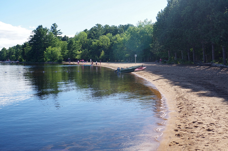
The spectacular sand beach at Bonnechere Provincial Park was once a delta that formed at the end of the last ice age.
Let's Imagine: Ottawa Area 570 Million Years Ago
Imagine looking at the Earth taken over time, starting 570 million years ago! What changes would you see in eastern Ontario, near the present location of Bonnechere Provincial Park?
Initially, you would see land that consisted of old, hard rock that we call the Precambrian Shield. That land was pulled apart of the ancient land mass started to break up. A long, narrow valley was formed and it stretched from Montreal, to Ottawa, to North Bay, to Sudbury area. Jump ahead many 568 million years to about 2 million years ago. Now you see a great glacier that covered all of Ontario. Blink your eyes for a split second and the next thing you see is that glacier melting away. By 10,000 years ago, the glacier would have been completely melted away from southern Ontario. A massive volume of water is released by the melting glacial. That meltwater went rushing across the southern Ontario landscape. The meltwater shaped the landscape by removing material, drilling into rock, and flooding the land to create massive lakes.
You have just imagined some of the geological processes that were essential to create three of the geological curiosities that characterize Bonnechere Provincial Park: a) the meandering Bonnechere River; b) oxbows along the Bonnechere River floodplain; and c) the fabulous sand beach along the shore of Round Lake.
Have you ever wondered how these geologic processes created these geologic curiosities?
Create a Large Valley To Contain Meltwater: Ottawa-Bonnechere Rift or Graben Zone
One chapter in the geological story of the present Bonnechere Provincial Park began about 600 million years ago when Ontario was part of a great and ancient landmass called Rodinia. About 570 million years ago, that landmass began to pull apart along two great, long, parallel faults. Faults are zones of weakness in the Earth where the rock has been broken. As the land separated, the land between these long, parallel faults dropped down to create a long, narrow valley. This pull-apart zone is called a graben (see Figure 1 below). The valley is called a rift valley. It was the breakup of the landmass Rodinia along those big, parallel faults that created the graben and the rift valley 570 million years ago.
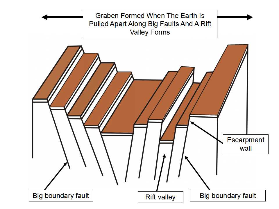
Figure 1: A cartoon that illustrates how a graben zone, with a rift valley, forms when the Earth is pulled apart along big, parallel faults. The central land area drops down to fill the space left by the left and right blocks as they are pulled apart. That is where the rift valley forms. There can be several smaller rift valleys within one larger graben zone. Image by E. Ginn, 2016.
Over geological time, the geological forces continued to pull the land apart. The land in the central zone continued to drop down. The rift valley got wider. The result was a long rift valley bounded on either side by a fault characterized by a steep cliff called an escarpment wall.
The graben and rift valley, which formed during the breakup of the landmass called Rodinia, extends for about 700 km from Montreal to Sudbury area (see Figure 2 below). The geological feature is called the Ottawa-Bonnechere Graben.
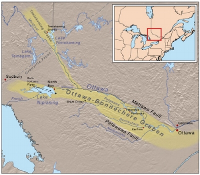
Figure 2: The geographic extent of the Ottawa - Bonnechere graben or rift valley extends about 700 km from the area near Montreal, west to the area near Sudbury. Image from from: https://en.wikipedia.org/wiki/Ottawa-Bonnechere_Graben
The big fault that defines the north boundary of the Ottawa-Bonnechere graben is called the Mattawa Fault. The south boundary of the Ottawa-Bonnechere graben zone is called the Petawawa Fault. To the north of the Mattawa fault stands the rugged Laurentian Mountains of Quebec - the remains of a once tall mountain chain. To the south of the Petawawa fault stands the rugged Opeongo Mountains of Ontario - also the remains of once tall mountain chain.
Within the Ottawa-Bonnechere graben, smaller faults formed between, but parallel to, the Mattawa and Petawawa faults. The smaller faults likely created a series of “steps” or smaller, flat valleys within the graben zone. In the area to the west and south east of Bonnechere Provincial Park, the flat floors of the rift valley within the Ottawa - Bonnechere graben was a key factor that controlled the location of the huge volumes of water that profoundly shaped the land over the past 10,000 years and that ultimately became the Bonnechere River and related lakes (see Figure 3 below).
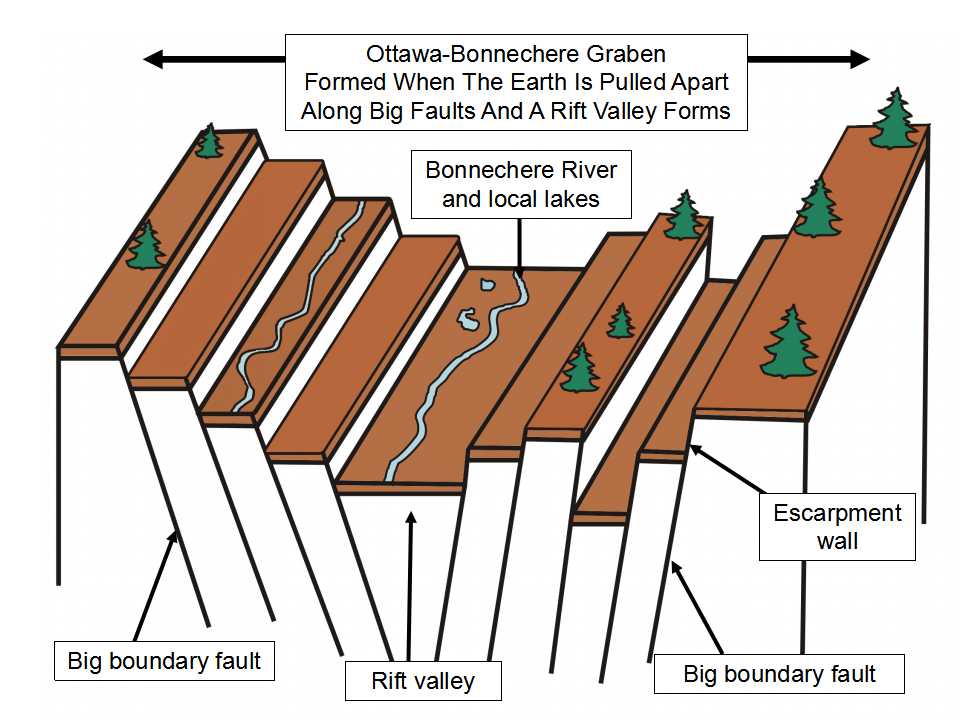
Figure 3: The Ottawa-Bonnechere graben and the internal valleys and faults were major factors that controlled the location of large volumes of water, which shaped the land and ultimately became the Bonnechere River. Image by E. Ginn, 2016.
Water...Water Everywhere: Where Did It All Come From?:
The ground preparation that created the Ottawa-Bonnechere graben started a long time ago. That creation of a relatively flat graben or rift valley, between two fault escarpments, was a key factor that contained and channeled the water of the ancestral Bonnechere River. However, the creation of the Bonnechere River was much more recent.
In the last 2 million years - a blink of the eye so to speak - all of Ontario, and almost all of Canada, was covered several times by sheets of ice, called a glacier (see Figure 4 below). This was the last great ice age to affect North America. At its peak, the glacier was about 1 km thick in the area we now call Bonnechere Provincial Park.
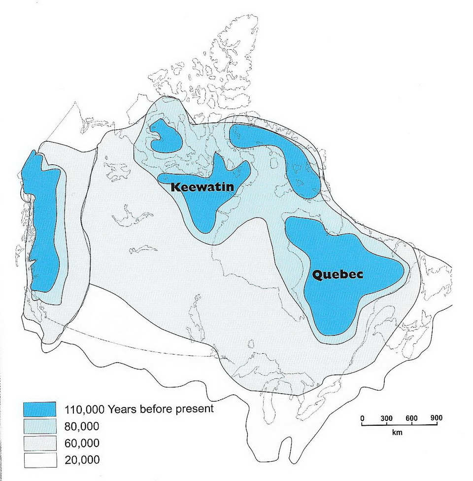
Figure 4: Cartoon that shows the extent of the glacier during the last ice age, which started about 2 million years ago and ended about 13,000 years ago in the area we now call Bonnechere Provincial Park. Images constructed from data provided by Arthur S. Dyke (2004).
The glacier ground up the hard Precambrian Shield rock into coarse to fine powder called “rock flower”, deposited that material as thick deposits beneath the glacier called till, and created other landforms as the glacier surged south and melted back to the north several times over the last 2 million years. However, about 15,000 years ago, the glacier started to melt in response to warming climate. Between 13,700 and 12,900 years ago, the last of the glacier melted in the area of Bonnechere Provincial Park and the land was once again exposed. Great volumes of water were released by the melting glacier. Locally, in the area of the land we now call Bonnechere Provincial Park, the meltwater was channeled along the Ottawa-Bonnechere rift valley - contained in an area called a spillway.
Figure 5 below shows what the ancestral Bonnechere River may have looked like at one time in its early history. The photo shows the Donjek River in Yukon. A melting glacier upriver releases a lot of meltwater. That meltwater rushes over the flood plain, carrying a lot of suspended sand to silt-sized material. Like the Donek River, the ancestral Bonnechere River was also fed by a remaining body of glacial ice located to the west, over what is now Algonquin Provincial Park. The ancestral Bonnechere River was likely also chocolate-coloured like the Donjek River.
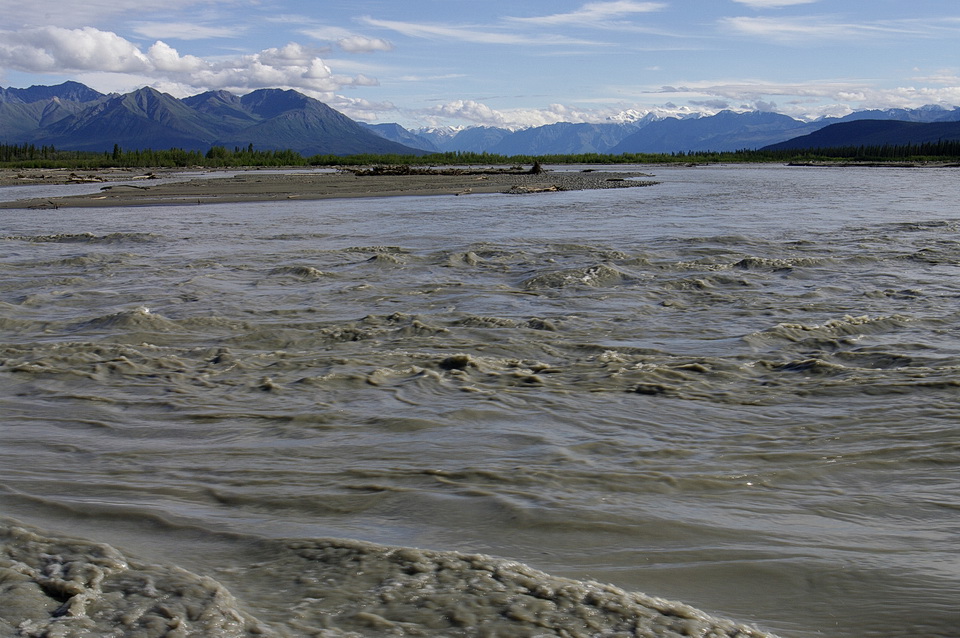
Figure 5: The Donjek River in Yukon is an analogue for the ancestral Bonnechere River. A melting glacier upriver releases a lot of meltwater which flows down the Donjek River, Yukon. That meltwater rushes over the flood plain, carrying a lot of suspended sand to silt-sized material. A delta formed where the ancestral Bonnechere River flowed into the ancestral Round Lake. Photo by Andy Fyon, August 1, 2008.
As a result of the power of the rushing meltwater flowing along the graben rift valley: a) the ancestral Bonnechere and other rivers formed and flowed along an area called a spillway; b) a large lake formed in the area of present day Round Lake; c) the river further shaped the land by carving out the material previously deposited by the glacier in the valley bottom and some of the bedrock.
The material carried by the ancestral Bonnechere River was eventually deposited when the river slowed down and lost its ability to carry suspended sands. One dramatic way for a glacial river to slow down is to flow into a glacial lake, where the river slows down, loses its ability to carry suspended material, and deposits the sand and gravel onto the bottom and sides of the river. This geological process creates a delta. A river delta is a geologic landform that forms when sandy and other material carried by the river is deposited where the rushing river enters slower-moving or standing body of water, like a large lake. Figure 6 below, from a Google Earth image, is an example of the delta that forms where a glacial river flows into Peyto Lake, Alberta. Before the river enters Peyto Lake, the river flows along a glacial spillway in a valley contained between two mountains. A lot of sand is deposited along that spillway on the flood plain as well as at the place where the river enters the lake. The flood plain spillway and the delta can cover a very large area, especially as the delta continues to expand and grow into the lake. The Bonnechere River delta formed where the ancestral Bonnechere River flowed into the ancestral Round Lake. The Peyto Lake delta is a good example of the way the Bonnechere River delta formed.

Figure 6: A delta is formed where a rushing glacial meltwater river enters Peyto Lake, Alberta. The rushing river is contained between two mountains that act very much the way the margins of a Ottawa-Bonnechere graben served to contain the ancestral Bonnechere River. When the river enters the lake, it slows down and can no longer carry the clay and sand particles. The sand and gravel particles drop out to form the delta. Image from Google Earth.
There is more evidence of the sandy delta and the sand that was deposited along the glacial spillway by the ancestral Bonnechere River. Southeast of Bonnechere Provincial Park, near Golden Lake, Highway 60 dips into what was a glacial spillway - a huge former river valley.
Evidence for the glacial spillway that contained the ancestral Bonnechere River is illustrated in Figure 7, below. The white- and brown-coloured parts of the image show high ground. The green- and light yellow-coloured areas represent low, relatively flat ground. An imaginary line joining points A, B and C trace out the floor of the rift valley where the ancestral Bonnechere River spillway was established. The imaginary line joining points E-D-E shows the southern margin of the Ottawa-Bonnechere graben - the Petawawa Fault escarpment. Lake Clear (D) developed along the fault escarpment. Golden Lake, point B, formed within the spillway. The former glacial spillway rans from Algonquin Park, through Bonnechere Provincial Park, to Eganville and on-wards to the southeast.
The deposits of sand that are so common in the Round Lake (area A) to Golden Lake (area B) area shows the power of the ancestral Bonnechere River and the size of the spillway and river delta that were created when the glacial meltwater rushed through this part of the Ottawa-Bonnechere graben valley.
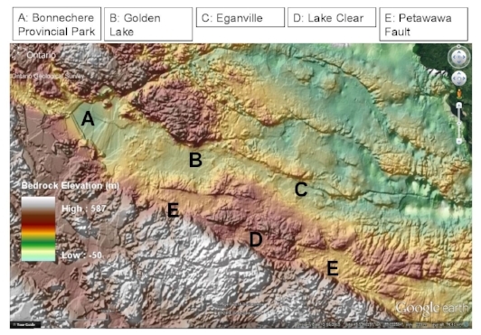
Figure 7: This depth to the rock basement images shows those areas of the basement rock that are topographically high (brown to white areas) and areas that are topographically low (light green). This type of image shows the Ottawa - Bonnechere graben rift valley very well (A, B, C) and the southern boundary Petawawa Fault E, D, E.
In summary, the melting of the glacier at the end of the last ice age created a huge volume of meltwater. That meltwater created the ancestral Bonnechere River, which was channeled through the Ottawa-Bonnechere rift valley. Sand carried by the ancestral Bonnechere River was dumped along the glacial spillway in the valley and formed a large delta where the river flowed into the large standing body of water that was the ancestral Round Lake. Today, we see that sand that was deposited along the spillway and at the top of the delta. That sandy ground covers a large area from west of Bonnechere Provincial Park to east of Golden lake. The fabulous sandy beach at Bonnechere Provincial Park is part of the sand deposited by the glacial meltwaters.
I Am So Slow That I will meander Along:
As the glacier continued to melt, the ice front retreated further to the north. In doing so, it contributed less and less meltwater to the ancestral Bonnechere River. As a result, the river flow slowed down and the ancestral Round Lake shrank to its present size. Because the rift valley was relatively flat, the ancestral Bonnechere River slowly changed its character. It changed from a rushing river fed by the massive volumes of meltwater to a slow, meandering river, like the river shown in the Figure 8, below.
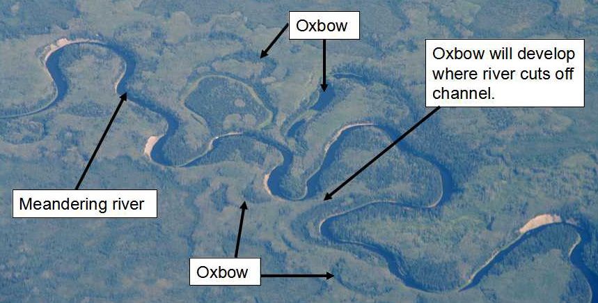
Figure 8: A meandering river located in northern Alberta, photographed from an aircraft. The river snakes back and forth as it flows over flat ground. The curves are called meanders. When the meander curve becomes so tight that it erodes the land separating the two, the curves join together and the river closes back on itself, creating a shortcut for itself. The original river channel is cut off, the former river channel becomes isolated and slowly starts to fill in with vegetation and sedimentary material. That isolated, former river channel is called an oxbow lake (see Figure 7, below). One such area is illustrated in the photo that will soon become an abandoned channel and then an oxbow. Photo by Andy Fyon.
When a river flows slowly over flat or gently sloping ground, it snakes back and forth. The curvy part of the river channel are called meanders. The outside edge of the river erodes and undercuts the river channel. This geological process allows the curvy, meander of the river to grow into a bigger, but tighter curve. Slowly, the river becomes full of loops and curves. That is the typical form of a meandering river. When the meander curve becomes so tight that it erodes the land separating the two, the curves join together and the river closes back on itself, creating a shortcut for itself. The original river channel is cut off and the former river channel becomes isolated. Once cut off, the isolated, or abandoned channel, slowly starts to fill in with vegetation and river deposits material. That isolated, former river channel is called an oxbow lake.
Geologically, the meandering Bonnechere River, with its cutoff oxbow lakes, is typical of a river that flows over flat or gently sloping land, in this case, within the Ottawa-Bonnechere graben valley.
Summary:
The key geologic factor that influenced the location of the Bonnechere Provincial Park area began 570 million years area, when an ancient landmass started to break up and pull apart along the Mattawa Fault on the north and the Petawawa Fault on the south. This process gave birth to the Ottawa - Bonnechere graben and its central topographically low rift valley. About 13,000 years ago, at the end of the ice age, the rift valley became a glacial spillway used by the ancestral Bonnechere River - a rushing river that was fed by an enormous volume of water from the melting glacier. That ancestral Bonnechere River cut into and removed material deposited by the glacier on to the rift valley. The surging river deposited those sands along the spillway and as a large delta that formed where the ancestral Bonnechere River flowed into the ancestral Round Lake. As the last of the glacier melted away, there was less and less meltwater to feed the ancestral Bonnechere River. The ancestral Bonnechere River changed from a rushing river to a slow flowing river that began to meander across the former glacial spillway.
Today, the present-day Bonnechere River follows along part of the ancient rift valley that lies between the southern boundary Petawawa Fault and a smaller fault that lies north of Couchain Lake. Turners Road and Basin Depot Road follow the smaller fault-bounded valley that had formed within the Ottawa-Bonnechere graben. This is not the only small valley that formed inside the larger graben zone. A second step valley lies just to the north of Gunns Road, bounded by other small faults within the graben. Oxbow lakes formed recently, within the last 10,000 years, along the meandering Bonnechere River where river channels were cut off and abandoned. As Round Lake shrank to its present-day level, the sandy delta deposits became exposed in the area as extensive sand plains, including the sand plain exposed along the Basin Depot Road and as the fabulous beach on Round Lake within Bonnechere Provincial Park.
So the next time you stand on the sand beach on Round Lake, or canoe and hike along the oxbows or the meanders of the Bonnechere River, recall that the conditions needed to form these geological curiosities began to about 570 million years ago when an ancient landmass began to pull apart, and culminated with the release of huge volumes of melting glacial water 15,000 years ago at the end of the last great ice age when all of Ontario lay beneath a frozen ice mass.
Other Resources:
Arthur S. Dyke (2004): An outline of North American Deglaciation with emphasis on central and northern Canada, contained in Quaternary Glaciations - Extent and Chronology, Part II: North America, edited by J. Ehlers and P.L. Gibbard, Development in Quaterary Science, 2.
Have A Question About This Note?
Andy Fyon, Aug 20, 2016; Sept 6/16; Oct 18/16; April 6/17