
Calcareous Glacial Drift and Plants, Fraserdale, Ontario, Canada
The composition of glacial drift has an influence on the types of plants that grow on that drift. For example, calcareous glacial drift would likely support plants that thrive on limy soil. In this note, I share an example of the influence of calcareous substrate on some types of plants present seen in the Fraserdale - Abitibi Canyon area, northeastern Ontario (Photo 1).

Photo 1: Geographic location of the Fraserdale and Abitibi Canyon area, northeastern Ontario, Canada. The Google Earth image was created on Aug 10, 2021.
Location
Fraserdale and Abitibi Canyon are located about 130 kilometres (81 mi) north of Timmins and about 160 km (100 mi) south of James Bay, in Ontario, Canada (Photo 1). The area is located in the northern Boreal forest and lies about 30-50 km south of the boundary between the Boreal Forest and the James Bay lowland.
Brief Geology of the Area
From a geological perspective, the James Bay lowland is part of the larger Hudson Bay - James Bay Lowland (Photo 2). Calcareous, Paleozoic-aged rocks, consisting of limestone and dolostone, underlie the Hudson Bay - James Bay lowland. The limestone and dolostone rocks are in turn covered by clay, sand, and gravel deposits that were laid down at the end of the last ice age. That ice age, called the Wisconsin Glacial Episode or the Wisconsin glaciation for short, ended about 11,000 years ago in this area when the ice sheet began to melt. After the ice sheet melted away, extensive peat deposits formed on top of the clay, sand, and gravel glacial deposits. Check here for more details about the recent geological history of the lowlands.

Photo 2: Location of the Hudson Bay and James Bay lowlands, denoted by the light green coloured area on the map. within the black circle. The simplified bedrock geological map is from the Ontario Geological Survey. The location of Fraserdale - Abitibi Canyon area is shown by the red dot.
The presence of limestone and dolostone rocks to the north of the Fraserdale area is important. During the last ice age, the glacier ground off rock flour and rock fragments from the calcareous, limestone and dolostone bedrock. Those materials were deposited as glacial till, at the base of the ice sheet (teal coloured area in Photo 3). The till is the oldest glacial deposit and it formed DURING the ice age. At the end of the ice age, when the ice sheet melted away, meltwater lakes and rivers were created with associated unconsolidated river, beach, delta, and lake bottom deposits (orange-, sandy-brown-, yellow-, and blue-coloured areas respectively on Photo 3). Geologists say these unconsolidated deposits are post-glacial in age - meaning they formed at the end of, and after, the ice age. Together, the undifferentiated glacial and post glacial surficial deposits are called glacial drift. The glacial drift lies on top of old Canadian Shield rocks that form the basement in the Fraserdale - Abitibi Canyon area (Photo 2). The most recent deposits, formed in modern times, consist of peat, muck and marl deposits that are shown in the mauve-grey-coloured areas on the surficial geology map (Photo 3).

Photo 3: Surficial geology of the Fraserdale area. A) Oldest surficial geological material consists of glacial till that was deposited at the base of the ice sheet (teal coloured area in Photo 3). B) The surficial gravel, sand, silt and clay deposits that formed when the ice sheet started to melt, created river, beach, delta, and lake bottom deposits that are coloured orange-, sandy-brown-, yellow-, and blue-coloured areas on the geology map (Photo 3. Together, the undifferentiated glacial till and post glacial surficial deposits are called glacial drift. C) The most recent deposits, consisting of peat, muck and marl, formed in modern times, and are shown in the mauve-grey-coloured areas on the surficial geology map (Photo 3). Image created using the free, online OGSEarth application provided by the Ontario Geological Survey (https://www.mndm.gov.on.ca/en/mines-and-minerals/applications/ogsearth/surficial-geology) superimposed on a Google Earth image.
For more insight about the local calcareous geology, check out: https://www.ontariobeneathourfeet.com/geological-sites#/fraserdale-glacial-drift .
Influence of Calcareous Drift
The calcareous drift supports calcicolous vegetation. Calcicolous vegetation is adapted to growing in limy conditions. In the literature and on websites, limy soil is sometimes referred to high pH bedrock or soil.
Examples of calcicolous plants observed in the Fraserdale area include: a) Marsh Grass of Parnassus (Parnassia palustris), growing on wet calcareous drift (Photo 4); b) Kalm's Lobelia (Lobelia kalmii), growing on moist calcareous drift (Photo 5); c) Sticky False Asphodel (Triantha glutinosa), which was fruiting and growing on moist calcareous drift (Photo 6); d) Hairy Goldenrod (Solidago hispida), which grows on a range of substrates, but which locally prefers calcareous substrate (Photo 7) and is very common in the Fraserdale area on calcareous drift; and e) Variegated horsetail (Equisetum variegatum), a calcicolous plant, is also growing in the moist calcareous soil with Kalm's Lobelia (Lobelia kalmii) and Marsh Grass of Parnassus (Parnassia palustris) (Photo 8).
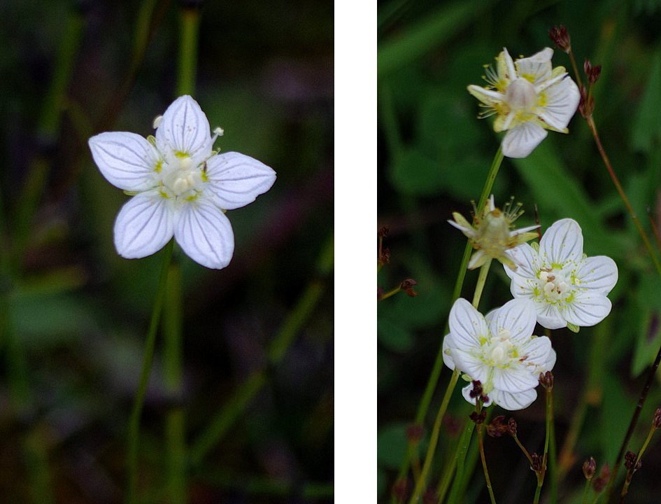
Photo 4: Marsh Grass of Parnassus (Parnassia palustris), growing on wet calcareous drift in the Fraserdale area, northeastern Ontario, Canada. Although poorly illustrated in this image, Variegated horsetail (Equisetum variegatum), a calcicolous plant, is also growing with the P. palustris. Photos by Andy Fyon, Aug 10/21.

Photo 5: Kalm's Lobelia (Lobelia kalmii), growing on wet calcareous drift in the Fraserdale area, northeastern Ontario, Canada. Photos by Andy Fyon, Aug 10/21.

Photo 6: Sticky False Asphodel (Triantha glutinosa), growing on wet calcareous drift in the Fraserdale area, northeastern Ontario, Canada. Photos by Andy Fyon, Aug 10/21.

Photo 7: Hairy Goldenrod (Solidago hispida), growing on dry, calcareous drift in the Fraserdale area, northeastern Ontario, Canada. Photos by Andy Fyon, Aug 10/21.

Photo 8: A poor image that illustrates variegated horsetail (Equisetum variegatum), a calcicolous plant, is also growing in the moist calcareous soil with Kalm's Lobelia (Lobelia kalmii) and Marsh Grass of Parnassus (Parnassia palustris), Fraserdale area, Ontario, Canada. Photo by Andy Fyon, Aug 10/21.
Summary
Although this is a small sampling of plants, seen late in the flower season, it does illustrate that the local, calcareous glacial drift in the Fraserdale area, northeastern Ontario, does have an influence on the local flora. The limy nature of the glacial drift is a direct reflection of the geological history of the area, principally, the scraping off of rock flour and fragments from the limestone and dolostone rock that occurs in the James Bay lowlands, just to the north of the area. Geology does influence the location of plant types.
Sept 8/21; Nov 15/21