
Ice Age: Glacial Erratic
A glacial erratic is a rock, or cluster of rocks, that was picked up, carried away, and deposited elsewhere by ice, like a glacier. Generally, the glacial erratic is different from the bedrock rock on which the erratic sits. That is, a glacial erratic is a foreign rock that generally does not come from the immediate area. The glacial erratic was transported from some other place. The glacial erratic just looks out-of-place (Photo 1).

Photo 1: Step A: an ice sheet plucks off a boulder of pink rock from the bedrock area where pink rock occurs. This is a type of erosion. Step B: The ice sheet transports the pink boulder away from its source outcrop. That transport distance can me meters to thousands of meters. Step C: When the glacier melts, the pink boulder is dropped or deposited on a different type of bedrock, in this case the blue bedrock. That is when the boulder becomes a glacial erratic. Image source: Glacial erratics.
Erratics can be carried on the top or bottom surface of a glacier. Erratics can also be carried by icebergs.
In Ontario and many places in Canada, glacial erratics are not rare. In fact, they are quite common.
What Does A Glacial Erratic Look Like?
Generally, a glacial erratic does not have sharp edges (Photo 2 and 3). The erratic tends to have a smooth surface and is “roundish”. If an erratic has broken after it was deposited, there can be sharp edges. Sometimes glacial striations, or glacial striae, occur on the surface.
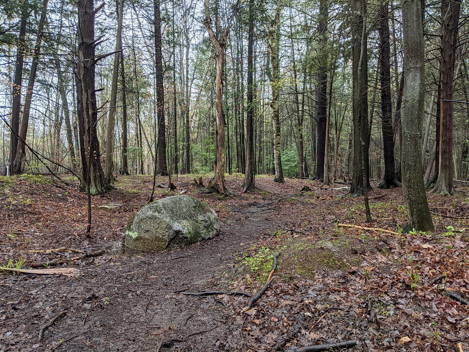
Photo 2: A glacial erratic located in Ottawa, Ontario, Canada. The glacial erratic looks out of place. This one is composed of Precambrian granite, yet the surrounding rock is Paleozoic limestone. It is likely that the glacial erratic was transported from the Precambrian Canadian Shield, located about 25 km to the north. Photo by Andy Fyon in the Pinhey sand dune forest, Ottawa, Ontario, Canada, April 30, 2021.
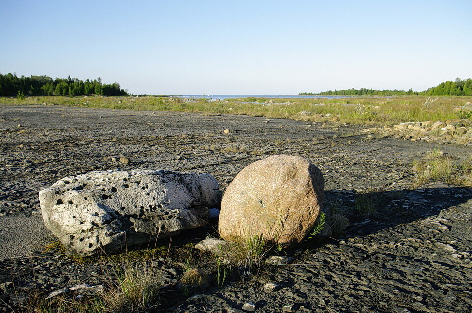
Photo 3: Glacial erratics that occur on a dolomite alvar pavement, Murphy Point, Manitoulin Island, Ontario, Canada. The glacial erratics consist of Precambrian rock. Not that the erratics do not have sharp corners of edges. They were transported at least 55 km (35 mi) from the north. Photo by Andy Fyon, at Murphy Point, Manitoulin Island, July 11, 2010.
How Far Can A Glacial Erratic Be Transported?
Glaciers can transport rock and ground up rock over distances of meters, to hundreds of kilometers. One important study shows that a distinctive glacial erratic rock type, called Omars, has been transported by an ice age glacier up to 2,000 km (1,240 mi) from its source area in Hudson Bay! That is a long way.
How Big Are Glacial Erratics?
Glacial erratics can range in size from pebbles to large boulders (Photo 4).
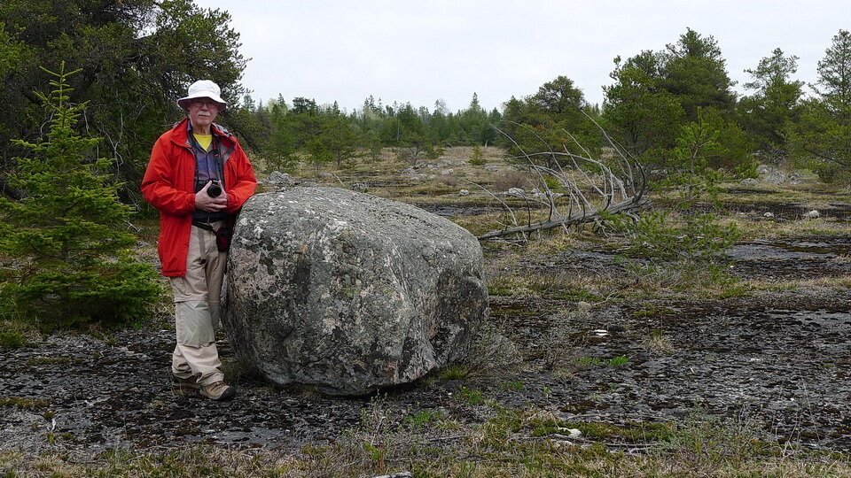
Photo 4: A glacial erratic consisting of Precambrian granite sits on alvar pavement consisting of Ordovician dolomite. Photo of Andy Fyon, Misery Bay Provincial Park, Manitoulin Island, Ontario, Canada, May 17, 2015.
One famous glacial erratic named “Big Rock”, or Okotoks Erratic, or just “Okotok” occurs near the town of Okotoks, Alberta (Photo 5). That erratic, which is broken into at least two pieces, is about 41 by 18 m (135 by 60 ft) and is 9 m (30 ft) high. It is estimated to weigh about 16,500-tonne (18,200-ton). It was transported about 930 km (580 mi) from its source.

Photo 5: The famous Okotoks Erratic, located in Alberta, Canada, is about 41 by 18 m (135 by 60 ft) and is 9 m (30 ft) high. It is estimated to weigh about 16,500-tonne (18,200-ton). It was transported about 930 km (580 mi) from its source. Photo by Andy Fyon, July 4, 2014.
When Did Glaciers Transport Glacial Erratics In Canada?
Canada was affected by several ice ages over time. We can expect that each ice age formed glacial erratics; however, each subsequent ice age would have destroyed the glacial erratics formed during the previous ice age. Therefore, the glacial erratics we see on the land today formed during the most recent ice age. The most recent ice to have affected Canada took place during the Pleistocene Epoch. That is defined as the time period, which began about 2.6 million years ago, and which ended about 11,700 years ago. During the Pleistocene Epoch, the land surface of almost all of Canada was covered several times by expanding and melting glaciers. The most recent glacial period that affected North America is called the Wisconsin Glacial Episode, or the Wisconsin glaciation. The Wisconsin glaciation lasted from about 75,000 years ago to about 11,000 years ago.
So, glacial erratics transported by an ice sheet, or glacier, would have moved between 75,000 years ago and 11,000 years ago. Glacial erratics moved by an iceberg would have carried glacial erratics until a slightly younger date.
Why Are Glacial Erratics Important?
Geologists study glacial erratics to better understand the history of the land. For example, some glacial erratics are made of a distinctive rock type, which means that their source outcrop can be identified and located. The presence of a glacial erratic can help us understand what path was travelled by a glacier, the timing when a glacier melted, also known as a glacial retreat, and even the type of glacier flow. Understanding the journey travelled by the glacier helps us understand the history of the land, the type of soil in an area, and even the general location an important mineral deposit.
Glacial erratics help us understand the history of the Earth.
My Favourite Glacial Erratics
I have several glacial erratics. I like these ones because they are different, big, or tell something about ways that humans or animals used the glacial erratic.
Bell rocks, La Cloche Island, Ontario
On La Cloche Island, located on land used to access a deep water port, north of Manitoulin Island, are three large rocks that were used to sound warning alarms to the local First Nation people who lived along the shores from Birch Island to Sheguindah. When struck with another rock, these large rocks rang out like a bell. That noise could be heard for miles. The ringing of the rock was the inspiration that led the French voyageurs to call the islands and area La Cloche, meaning “The Bell”.
It is not clear to me that these are glacial erratics, or if the rocks have been moved to their present location for security reasons; however, their overall smooth surface and rounded form does resemble a glacial erratic. The rocks are informally named Bell Rocks (Photo 6).
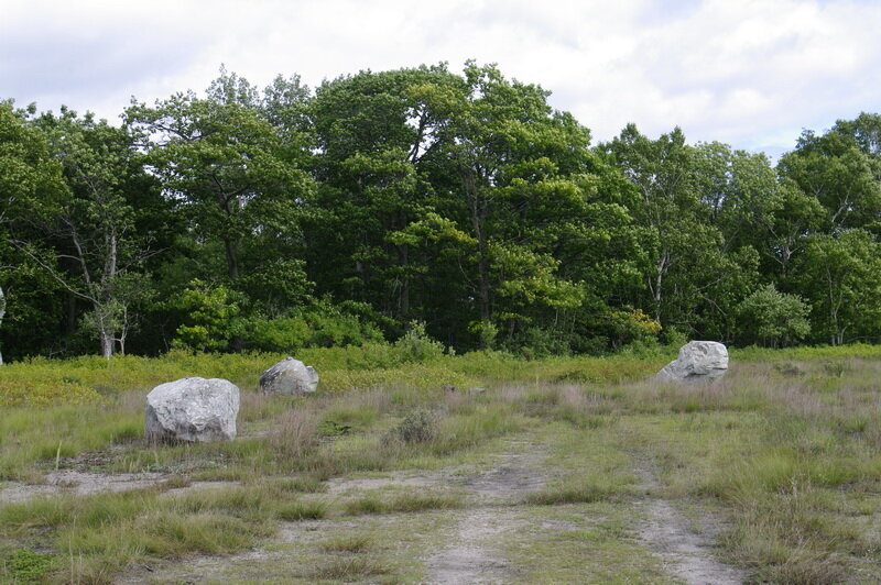
Photo 6: The three Bell Rocks, located on private property, in the La Cloche area, north of Manitoulin Island, Ontario Canada. It is said these rocks were used by local First Nation people to send alarms over great distances. The Bell Rock resonate when struck by smaller, hand-held rocks, and that resonance sounds like a bell. Please note that rocks should be treated as sacred, and I do not encourage anyone to hit the rocks. If you visit, please seek the company of a local First Nation person familiar with the history and significance. Image by Andy Fyon, Aug 27, 2014.
Pits or cup-shaped depressions occur on the surface of the rocks (Photo 7). Those pits are thought to have been formed from the concussion of a smaller, hand-held rock against the big Bell Rock.

Photo 7: Pits on the surface of the Bell Rocks appear to have been formed by the concussion of smaller hand-held rock used to create the bell sound. If you visit, please seek the company of a local First Nation person familiar with the history and significance. Image by Andy Fyon, Aug 27, 2014.
When struck with another rock, the Bell Rocks do indeed resonate like a bell. You can Google “bell rocks” to find a YouTube video of the resonating rock when hit by another rock. Please note that rocks should be treated as sacred, and I do not encourage anyone to hit the rocks, unless guided by a local First Nation person familiar with the history and significance.
Buffalo rub rock, Alberta
An odd boulder sits alone on a prairies near Onefour, in southern Alberta (Photo 8). We visited this rock with the Director of the local Agriculture Canada research centre. The rock is interpreted to be a “buffalo-rub rock”. Buffalo would rub against the rock to remove hair, ticks, and to enjoy a good rub. The rubbing is thought to have smoothed the rock surface. A depressed ditch surrounds the rock. That ditch is said to have been created by long-term use by buffalo who circled the rock as they rubbed. Again, I am not 100% certain that this is a glacial erratic, but its isolated occurrence on the prairie suggests transport by ice is a reasonable explanation. Glacial erratics were used by animals.
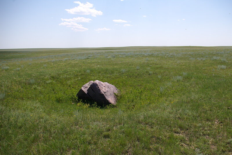
Photo 8: A likely glacial erratic that sits isolated on the prairie, near Onefour, southern Alberta, Canada. The ditch around the boulder and the smoothed surfaces are said to have been created by buffalo who rubbed against the boulder over many years. Image by Andy Fyon, June 28, 2005
Glacial erratic, Carlington Woods, Ottawa
While not a spectacular glacial erratic, this one sits, ornamented with
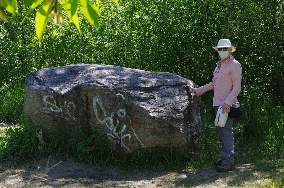
Photo 9: A glacial erratic sitting on top of limestone in the Carlington Woods area, Ottawa, along one of the hiking trails. The erratic consists of Grenville gneiss (see phot 10, below, for close-up view of gneissic textures. Photo Andy Fyon, May 31/21.
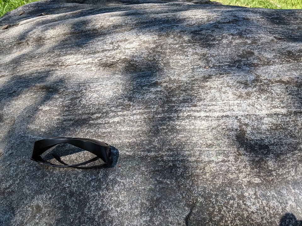
Photo 10: Close-up of the glacial erratic sitting on top of limestone in the Carlington Woods area, Ottawa. The lamination is typical of gneissic rock. I assume this rock was transported from the Quebec, across the Ottawa River. The erratic likely consists of Grenville gneiss. Photo Andy Fyon, May 31/21.
Omar glacial erratic, Fort Severn, Ontario
This Omar glacial erratic occurs along the shore of Hudson Bay, just north of the First Nation community of Fort Severn, Ontario (Photo 11). These glacial erratic rocks are quite famous in geological circles (Prest et al., 2000). Their distribution across the southern Hudson Bay area, Ontario, Manitoba, Saskatchewan, and several adjoining northern states in United States informs us about the direction of Wisconsinan glacial dispersion during the last ice age.
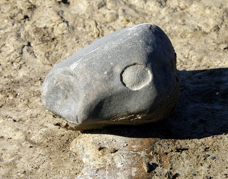
Photo 11: A type of glacial erratic called a “omar”. This type of glacial erratic consists of distinctive Proterozoic rock from the Omarolluk Formation of the Belcher Group, exposed on the Belcher Islands, of southeastern Hudson Bay. The glacial erratic rocks are composed of massive siliceous wacke characterized by buff-weathering calcareous concretions (Prest et al., 2000). Photo by Andy Fyon, on the south shore of Hudson Bay, Ontario, July 7, 2011.
These distinctive Proterozoic glacial erratics were derived from the Omarolluk Formation of the Belcher Group, exposed on the Belcher Islands, of southeastern Hudson Bay. The glacial erratic rocks are composed of massive siliceous wacke characterized by buff-weathering calcareous concretions (Prest et al., 2000). They are named “omars”.
The distribution of omars across North America tells us that the Wisconsinan ice sheets flowed northwestward, westward and southward for hundreds of kilometres across Hudson Bay, Northern Ontario, western Canada, and several adjoining northern States. Some omars were transported 2300 km (1430 mi) to Lethbridge, Alberta, Canada, and as far south as 1800 km (1110 mi) to the Chicago area, Illinois, USA (Prest et al., 2000)!!
The omar distribution is an illustration that helps us understand the distances that continental ice sheets are capable of travelling and transporting material picked up from the bedrock.
Additional photographs:
A glacial erratic located along the Lonesome Bog Trail, Esker Lakes Provincial Park, Ontario.

A glacial erratic located along the Lonesome Bog Trail, Esker Lakes Provincial Park, Ontario. Photo composed by Andy Fyon, Aug 7, 2021.
Have A Question About This Note?
Webpage URL: https://www.ontariobeneathourfeet.com/geological-sites#/ice-age-glacial-erratic
May 1, 2021; May 7/21; June 21/21; Nov 5/21