
The Geological Story of the Potholes, Rockwood Conservation Area
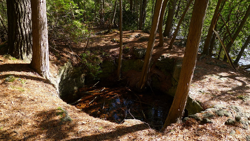
A typical pothole preserved at the Rockwood Conservation Area, along the Eramosa River. The diameter of the pothole is about 2 metres. May 2, 2015
The Rockwood Conservation Area contains several caves and hundreds of potholes. These geological curiosities are a source of wonder and interest by those who visit the area each year. I think we have a good understanding what a cave is. But what about a geological pothole? A geological pothole is a cylindrical hole, or pit, that occurs in solid rock. It is shaped like an empty paper towel tube. In this story, we will find out how this type of pothole formed.
Rockwood Conservation Area is not the only area that contains potholes. Potholes occur singly or in large numbers across Ontario: 1) central Ontario (Wawa - Chapleau area; La Cloche Mountains north of Little Current and Whitefish Falls area; 2) northeastern Georgian Bay, near the French River; 3) beside Highway 17, east of Serpent River; 4) in the Bruce Peninsula area; 5) southern Ontario (Warsaw Caves area near Peterborough; Chippewa Falls north of Sault Ste. Marie; Rockwood - Guelph area; along the Ottawa River in the Renfrew area) and 6) likely in rocks across Ontario's Far North. In these geographically diverse areas, potholes formed in a wide range of different rock types.
Let's Imagine: Ontario 13,000 Years Ago
Imagine standing on the land we now call the Rockwood Conservation Area about 13,000 years ago. What would the land have looked like? Was it a desert? Was it forested like today? Were there pre-existing potholes up to several meters across in the rock? At about 20,000 years ago, the land now occupied by the Rockwood Conservation Area was covered by ice - by a glacier (Figure 1). In fact, just about all of Canada was covered by a glacier. It was the time of the ice age. Recall that a glacier is made up of snow that fell over many years. As the snow accumulates, it is compressed and turns into a large, thick blanket of ice that can be 1 or more kilometers thick!

Figure 1: An illustration showing the location of the glacier across North America at about 13,000 years ago. The glacier is coloured blue-white. Land that was ice-free is coloured yellow. The red triangle shows the approximate location of what is now called Rockwood Conservation Area. The land near what we now call the Rockwood Conservation Area was ice free at this time because the glacier melted due to a warming of the global temperature. Image from: Dyke, A S; Prest, V K. Geological Survey of Canada, "A" Series Map 1703A, 1987, ; 3 sheets, doi:10.4095/133927
The land would have looked something like the photo below (Figure 2)! Of course, there were no mountains in Ontario 20,000 years ago, so just ignore the mountains.
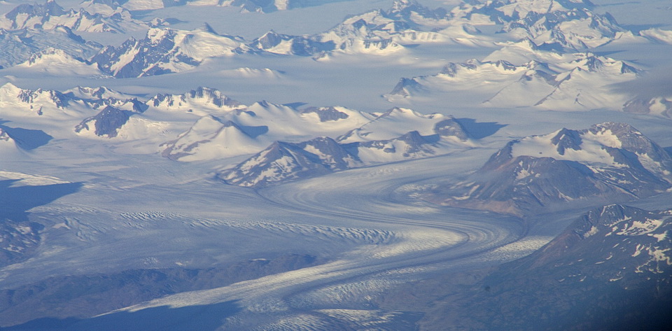
Figure 2: This is a photograph of an alpine glacier in British Columbia. While not directly analogous to the continental glacier that covered all of Ontario 2 million years ago, the image does illustrate the extensive cover of ice that is possible during a period of time when glaciers covered almost all of Canada. Photo by Andy Fyon, August 5, 2008.
By about 13,000 years ago, a lot had changed. The average global temperature had warmed and the glacier that covered all of Ontario, and most of Canada, began to melt back. As the glacier melted, land was exposed, once again, to the Sun. About 13,000 years ago, the land that was near the present area of the Rockwood Conservation Area was exposed to the Sun (Figure 3). Note that glacial ice still existed in the region. The remaining glacial ice filled the basin that would become Lake Ontario and glacial ice still covered most of the land to the west, north and east (Figure 3).
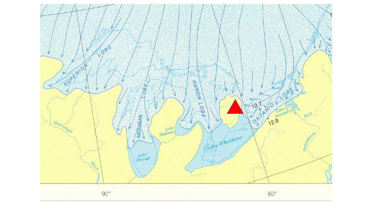
Figure 3: An illustration showing the location of the Rockwood Conservation Area (red triangle) and the glacier across part of southern Ontario at about 13,000 years ago. The glacier is coloured blue-white. Land that was ice-free is coloured yellow. The land near what we now call the Rockwood Conservation Area was ice free at this time because the glacier melted due to a warming of the global temperature. Image from: Dyke, A S; Prest, V K. Geological Survey of Canada, "A" Series Map 1703A, 1987, ; 3 sheets, doi:10.4095/133927
The temperature during a summer day in area where Rockwood Conservation Area now sits would have been cold, because you would have been standing only a few kilometres from the front of the glacier (Figure 3). The land was not covered by forests. Rather, the land was covered by sand and gravel material that had been deposited by the glacier. A few arctic plants would have started to colonize the exposed land. Figure 4 illustrates what parts of the landscape near Rockwood Conservation Area looked like where it was free of glacial ice and exposed to the Sun. Of course, the mountains would not have existed 15,000 years ago in Ontario, so just ignore them!
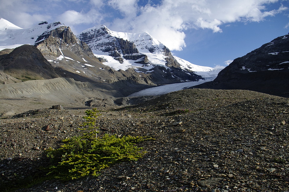
Figure 4: This photo of the Athabaska glacier, Alberta, in the Rocky Mountains, illustrates what parts of southern Ontario likely looked like when the last glacier melted back about 15,000 years ago to expose the land to the Sun. The gravelly material is called a glacial moraine and it is deposited by the glacier. Some willows and alpine plants and shrubs repopulate the land quickly, within 40 years or less. Photo by Andy Fyon, July 22, 2011.
Across the ice-free land, you would have seen large, relatively flat areas of sandy material called glacial till (Wentworth till), which was deposited beneath the glacier. On parts of this flat till material, you would see tear-drop shaped sandy hills called drumlins (Guelph drumlin field) that are aligned in a west-northwest direction (Figure 5). These drumlin hills formed beneath the glacier as it rode over older till material left by the glacier.
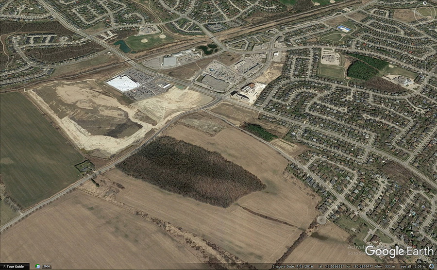
Figure 5: A drumlin west of the City of Guelph, located between Whitelaw Road and Elmira Roard South. This drumlin is part of the Guelph Drumlin Field. A drumlin is an elongated hill that is shaped like a tear-drop or inverted spoon. It is formed by a glacier that rode over and shaped the underlying unconsolidated till or ground moraine. Image is from Google Earth, November 2/16.
You would have seen gravel-rich ridges, called end-moraines, aligned in a northeasterly direction across the area. The ridges were deposited from of the glacier when it stopped moving. These gravel-rich end-moraines would have looked similar to those shown in Figure 4 (above), without the mountains.
You would also have seen great rushing rivers flowing away from the front of the melting glacier. The rivers were fed by water released by the melting glacier. These meltwater-fed rivers would have: a) cut deep valleys into the previously deposited material, including the bedrock (important in pothole formation); b) spread suspended material over a wide area called an outwash plain in front of the glacier, where the rivers carried a lot of suspended material and flowed over relatively flat land; c) formed long, snake-shaped ribbons of gravel-rich deposits, called eskers, where the rivers flower under the melting glacier; and d) formed local lakes, with material deposited on the bottom of the lake, where the rivers were dammed by ice or pre-existing material deposited by the glacier. The meltwater-fed rivers carried a lot of fine silt, sand and gravel. This transported material is called suspended material. The suspended material was deposited by the rushing river once the river flow decreased to the point where the river could not carry the material. One of these rivers was the Eramosa River, parent to the present-day Eramosa River (Figure 6).
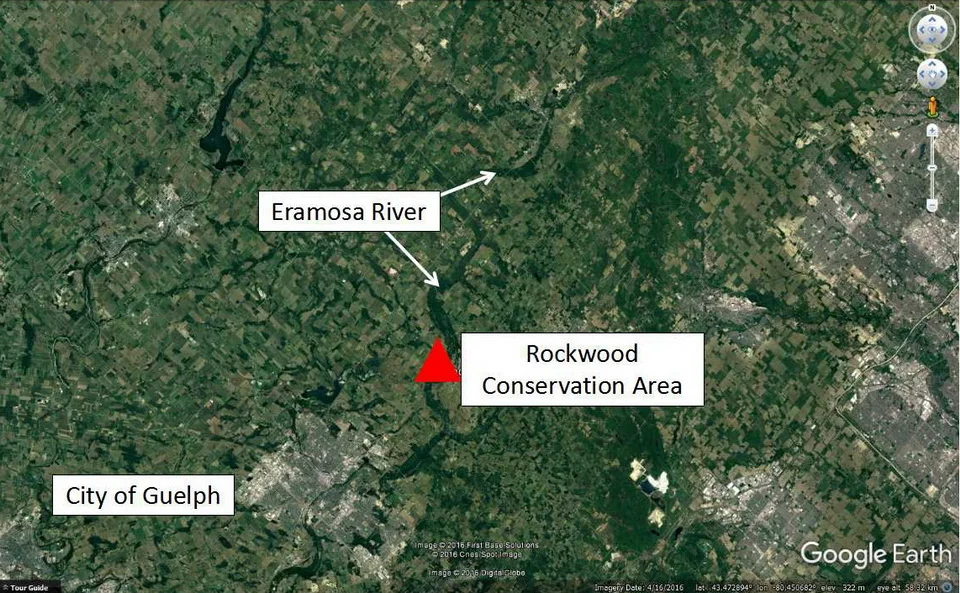
Figure 6: A Google Earth image that shows the location of the City of Guelph and the location of the present-day Eramosa River. The present-day Eramosa River flows within a deeper and wider river valley that was cut by ancestral meltwater rivers that flowed away from the glacier. The ancestral meltwater river was fed by an enormous amount of water that was released as the glacier melted. The ancestral Eramosa River cut down through the deposits left by the glacier and in some cases, cut into the underlying 425 million-year old dolomite rock of the Amabel Formation. This is a testament to the destructive power of powerful meltwater rivers.
To summarize, Figure 7 shows many of the landforms that would have been visible, had you been able to stand on the land near what we now call the Rockwood Conservation Area 13,000 years ago.
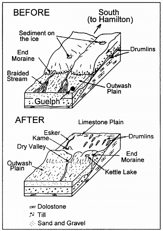
Figure 7: Glacial landforms that were created in the Guelph area during and at the end of the great ice age as the glacier melted away. Image from: W. Chesworth, P. Martini, P. McCarthy, and S. Sadura (1997) Geology and Land Use Between Guelph and Hamilton: A Self-guided Tour, Department of Land Resource Science, University of Guelph.
The Rock Beneath The Glacial Deposits in The Rockwood Conservation Area
In the Rockwood Conservation Area, the rock that contains the potholes is called dolomite. This rock is about 425 million years old! The rock has its origins as limy mud on the bottom of a warm tropical ocean. As that limy mud built up on the bottom of the tropical ocean, it became thicker and thicker. The limy mud was squeezed and heated by the weight of the overlying material. That "cooking" and squeezing turned the limy mud into a hard rock called limestone. With additional cooking and reaction with water that was trapped in the wet limy muds, the limestone was changed again into a rock called dolomite. This dolomite rock is widespread across southern Ontario, from Manitoulin Island to southern Ontario. Geologists have given a special name to the dolomite rock. It is called the Amabel Formation.
Now For Something Completely Different: Potholes
At Rockwood Conservation Area, potholes range in size. Some are as small as a few centimetres across. Others are several metres across (Figure 8). The largest pothole in this region occurs near Richardson Creek on the southeastern part of the University of Waterloo property. This huge pothole is called “Devil’s Well”. It is more than 13 metres deep and 6 metres wide. You could fit two city buses side-by-side at the bottom! The wall of some potholes is marked with grooves that spiral downward. Some potholes have a low central hump on the floor of the pothole. Locally, one pothole is superimposed on another.
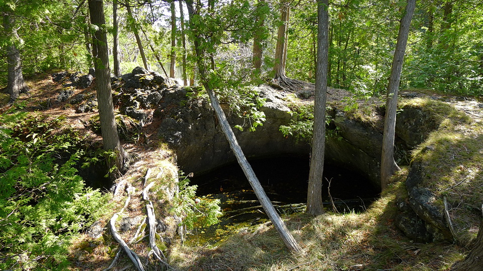
Figure 8: A large pothole among the eastern white cedar trees at the Rockwood Conservation Area. The diameter of this pothole is about 2 metres. Photo by Andy Fyon, May 2, 2015.
How Do You Create A Pothole?
Geologists generally agree that the potholes formed during, and at the end of, the last of the ice age. Key to the formation of the potholes was the melting of the glacier, when an enormous volume of glacial meltwater was released to form rushing meltwater rivers, like the the ancestral Eramosa River. To create a pothole in solid rock, Mother Nature had to "drill" into the dolomite rock and remove the rock material.
A huge amount of water was stored as ice in the glacier. In the Rockwood Conservation area, the glacial ice melted quickly as the climate warmed and an enormous amount of meltwater was released. Some of the meltwater flowed along the bottom of the glacier where it was under super high pressure. Some meltwater flowed out from beneath the glacier to create rushing rivers. We know the volume of meltwater released was huge and the meltwater river was powerful because the width of the Eramosa River is much wider compared to the width of the present-day Eramosa River (Figure 9). The much wider river valley was carved out by a much larger ancestral river - one that was much larger than the present Eramosa River.
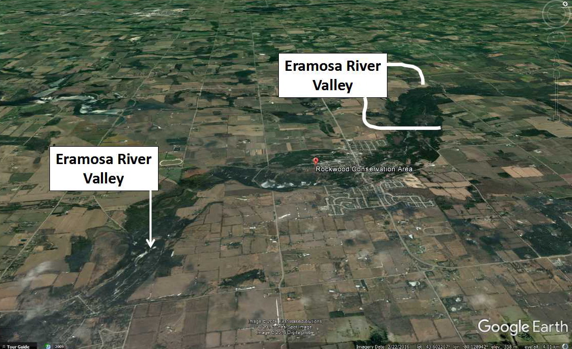
Figure 9: The width and depth of the Eramosa River valley is much larger than could be created by the tiny, present-day Eramosa River.This tells us that the ancestral Eramosa River was much larger and more powerful than the present-day Eramosa River. Geologists conclude that periodic and likely catastrophic floods of meltwater were released during the melting of the glacier 15,000 to 12,000 years ago. That huge volume of meltwater was the force required to transport pebbles and to have those pebbles drill into the dolomite rock on the river bottom.
The huge volume of glacial meltwater created swirling, rushing, powerful rivers that carried sand, pebbles, and sometimes even large boulders. When those meltwater rivers were focused along a narrow channel, over a very short period of time, the rivers and their suspended pebbles were capable of drilling into the floor made of Amabel Formation dolomite rock.

Figure 10: This cartoon illustrates the geological process that created the potholes. A swirling water current carrying small pebbles and sediment wore away and "drilled" into the rock on the river bed. .Image from: http://www.geo.mtu.edu/KeweenawGeoheritage/The_Fault/Potholes.html
The potholes started to form when one of more hard pebbles, carried by the meltwater rivers, became stuck into cracks or cavities in the dolomite rock river bed. The incredible force of the rushing meltwater river caused the rock pebble to swirl around and around within the rock crack and to "drill" into the rock along the bottom of the main river channel or in plunge pools below cataracts or water falls (see Figure 10).
Grooves that spiral downward along the walls of some potholes trace out the path of the "drilling" rocks that swirled in the meltwater vortex. Some "drilling" pebbles swirled around on the outside of the bottom of the pothole leaving a low central hump on the floor of some potholes. Sometimes hard, well rounded rocks occur at the bottom of a pothole. These are the remains of the rock that was responsible for "drilling" the pothole. The presence of potholes on dry land trace out the path of former meltwater river channels or cataracts where potholes were originally created. One pothole superimposed on another suggests a history of pothole formation in response to successive, high volume releases meltwater. Some potholes may also have formed under the glacier in river channels where the meltwater flowed under great pressure under the melting glacier.
The meltwater rivers had the power needed to "drill" into the Amabel dolomite that formed the river bed.
Why Are There So Many Potholes In This Area
Many geologists agree that the Eramosa Valley is part of a complex series of meltwater channels that drained from the margins of the melting glacier. The large number of potholes in the Rockwood Conservation Area, and the nearby University of Waterloo area, appear to be associated with localized catastrophic floods of meltwater related to the melting glacier 15,000 to 12,000 years ago.
Summary
Many potholes occur in Amabel Formation dolomite rock in the Rockwood Conservation Area. Although the Amabel Formation dolomite formed about 425 million years ago, the key geological process responsible for creating the potholes took place under, or close to a great melting glacier that covered all of Ontario 17,000 years ago.
Long after the Amabel Formation dolomite rocks formed, the area was covered periodically by a glacier that surged south and melted back to the north several times between 2.5 million years ago and 17,000 years ago. The key geological process responsible for the creation of the potholes was the catastrophic release of water released by the final melting of that glacier about 15,000 to 12,000 years ago. The roaring meltwater rivers carried silt, sand, pebbles and small boulders. The force of that swirling meltwater rivers caused pebbles and small boulders to attack and locally "drill" into the dolomite rock along the river channels. The modern flow of the Eramosa River pales compared to the what the flow must have been when the glacier was melting.
So, the next time you stand by a pothole, think of what the area must be looked like when the cold, rushing meltwater rivers attacked the rocks that make up the Ontario Beneath Your Feet.
Potholes From Other Areas:

Potholes (highlighted by the red arrows) are developed in limestone rock along the Mistaya River, exposed in the Mistaya Canyon, Banff National Park, Alberta. The Mistaya River starts in Peyto Lake, another tourist destination, and flows into the North Saskatchewan River. In this canyon, swirling waters carrying grit and cobbles, carved the potholes into solid limestone rock. I read that the word “Mistaya” means Grizzly bear in the Cree language. Image: Andy Fyon, June 28/14.
Some Sources of Information:
There are several excellent summaries of pothole formation in Ontario, including:
b) Arthur S. Dyke (2004): An outline of North American Deglaciation with emphasis on central and northern Canada, contained in Quaternary Glaciations - Extent and Chronology, Part II: North America, edited by J. Ehlers and P.L. Gibbard, Development in Quaterary Science, 2.
c) Dr. Paul Karrow, Department of Earth and Environmental Sciences, University of Waterloo: "Potholes" (https://uwaterloo.ca/wat-on-earth/news/potholes).
d) Kunert, M. and Coniglio, M. 2002. Origin of vertical shafts in bedrock along the Eramosa River valley near Guelph, southern Ontario. Canadian Journal of Earth Sciences, v. 39, p. 43.52.
e) Dr. Alan Morgan (University of Waterloo):"Glacial Potholes" (https://uwaterloo.ca/wat-on-earth/news/potholes).
f) Mistaya Canyon, Alberta: https://solotripsandtips.com/mistaya-canyon-banff-national-park/
Andy Fyon, August 20, 2016; modified September 23/16; Nov 11/16; April 6/17; March 22/22.