
Geochemistry: Clints and Grikes
In this note, I describe the formation of the karst features called clints and grikes (grykes) in limestone and dolostone (Photo 1). Clints and grikes are a type of karst feature formed when slightly acidic water dissolves limestone and dolostone. Perhaps you have seen a flat outcrop of bare limestone. Chances are that you may have noted that there are flat, table or pavement-like areas separated by open cracks or fissures. The clints are the flat, pavement-like limestone areas. The grikes are the open cracks, or fissures, which isolate the individual clints. The shapes and sizes of the clints depends on the distribution and orientation of the grikes.
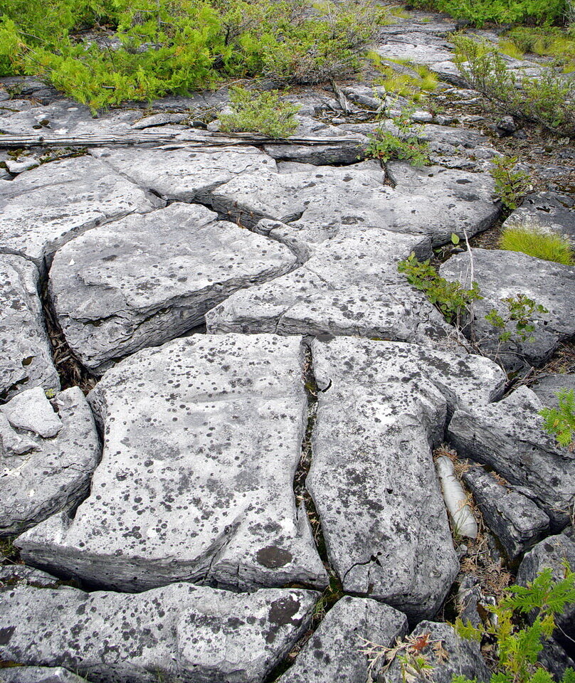
Photo 1: The open fissures are grikes (grykes). The flat, pavement areas between the grikes are called clints. These are karst features developed in limestone and dolostone. Photo composed by Andy Fyon, at Misery Bay Provincial Park, Manitoulin island, Ontario, Canada, Aug 23, 2010.
Let’s look at the process that led to the formation of the clints and grikes.
Geological Context
To understand how clints and grikes formed, we have to have a simple understanding of the rock that contains the clints and grikes and the geological history those rocks enjoyed.
Part 1: Limestone and dolostone
Parts of Canada are covered by limestone and dolostone rock. Limestone (CaCO3) is made of two chemical components: a) the chemical element called calcium; and b) the chemical carbonate. Dolostone [CaMg(CO3)2] is made of: a) the chemical elements calcium and magnesium; and b) the chemical carbonate. In Ontario, the limestone and dolostone occurs in two geographic areas (Photo 2): a) southern Ontario; and b) along the shore of James Bay and Hudson Bay. Those Ontario rocks started to form about 540 million years ago and stopped forming about 360 million years ago. The fossils and other geological features contained in those rocks tell us that the limestone and dolostone formed when this part of the world sat along, or close to, the equator. That’s right! Ontario was once a tropical land. In addition, large parts of Ontario were covered by warm, shallow, tropical seas that contained abundant life. The limestone and dolostone formed on the bottom of that warm tropical ocean.

Photo 2: Simplified bedrock geology of Ontario, showing the distribution of the old Canadian Shield rocks, named Archean and Proterozoic) and the younger Phanerozoic tocks. Limestone and dolostone rocks occur in the Phanerozoic packages. Those limy rocks occur in the south and along the shores of James Bay and Hudson Bay. Image derived from Ontario Geological Survey.
Part 2: The geological interlude
A lot of geological history took place after the formation of the limestone and dolostone rock. We won’t consider that history right now. Instead, in Part 3, we will jump forward to a more recent time about 2.5 million years ago (2,500,000 years ago).
Part 3: The last ice age
During the last 2.5 million years (2,500,000 years), the Earth experienced an ice age and parts of the Earth’s northern hemisphere were variably covered by ice sheets. Scientists call this the Pleistocene Ice Age. It may be hard to believe we are in an ice age today because glaciers around the world are melting and the land called Canada is almost completely free of ice, except for some glaciers in the Rocky Mountains. However, over the last 2.5 million years, parts of the northern hemisphere were completely covered by ice several times. During this last 2.5 million years, the Earth’s climate periodically warmed and cooled. When the climate warmed, the glaciers melted. When the climate cooled, the glaciers grew.
One reason the glaciers are melting so quickly today is attributed to the impact of a warming climate, but that is not the focus of this note.
During the last 75,000 years, Canada was covered by ice sheets during what geologists call the Wisconsin Ice Age. That ice age ended about 11,000 years ago, although many alpine glaciers still exist today. In North America, the ice sheet was thickest about 25,000–21,000 years ago. At that time, glaciers deposited till directly upon the basement rock.
Locally, the sand, gravel and till, called surficial material, were cleaned off the rock surfaces by the combination of scouring glaciers and melt waters that formed lakes and rivers when the glaciers started to melt. That scouring exposed exposed and polished the basement rock. Where the basement rock was limestone or dolostone, large areas of bare, limy rock were exposed to the Earth’s atmosphere. The flat, polished, barren limy rocks are called pavements (Photo 3), or limestone barrens in some areas. The creation of limestone and dolostone pavement was a second important step leading to the formation of clints and grikes.
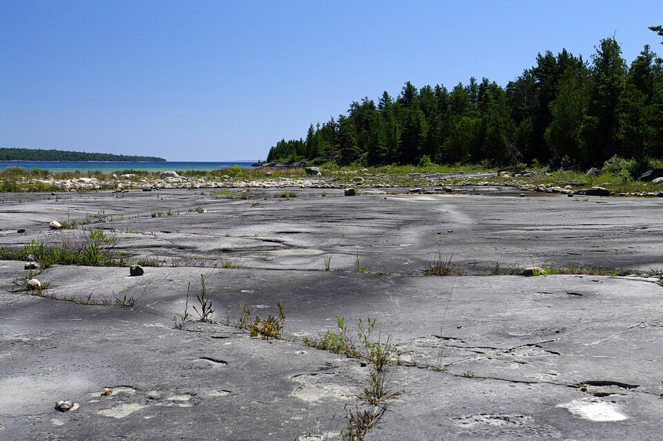
Photo 3: A large, flat, open area on dolostone. This flat area is called pavement. Image by Andy Fyon, Burnt Island harbour area, western Manitoulin Island, Ontario, Canada, July 3/10.
Water Eats Rock
Pure water is slightly acidic because it reacts with gases in the Earth’s atmosphere. Rain water that falls on the can become more acidic if it soaks into the soil, where it reacts with soil gases created by plant roots. Because of the limestone and dolostone chemistry, those rocks are slightly soluble in acidic water. That means, under the right conditions, slightly acidic water will dissolve - or eat - the limestone and dolostone rock.
The acidic water penetrates the rock along cracks or other planes of weakness. The rock walls of the crack or plane of weakness are dissolved by the water and an open fissure is formed.
The open fissure is called a grike (Photo 4).
The flat, table-top-like slabs of rock that sit between the grikes are called clints (Photo 4).
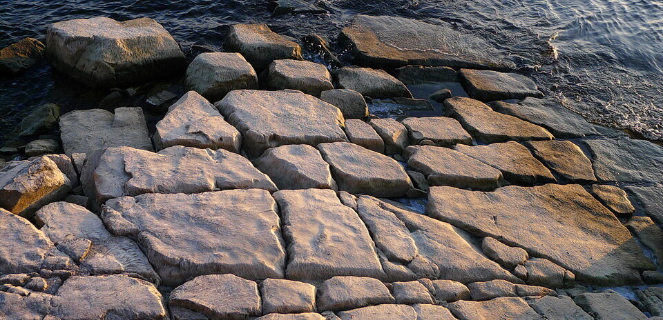
Photo 4: The straight open fissures in the limestone rock are called grikes. The flat table-like pavement areas are called clints. Grikes and clints are karst features that develop when slightly acidic water dissolves the limestone or dolostone rock along cracks and fractures. Photo composed by Andy Fyon, along the shore of Lake Ontario, at Lake Ontario Park, Kingston, Ontario, Canada, Dec 22, 2014.
The grikes can extend for a few centimetres to many metres along the surface. The grike may suddenly stop or they may become lost to our eye beneath soil cover. The grikes also extent for several metres below the surface. The grikes are usually straight (Photo 4), but they can be curved in shape (Photo 1). If the grikes are straight and the surface of the clints are roughly the same size, the clints begin to look like human-made paving stones (Photo 5).
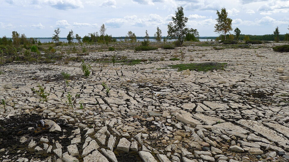
Photo 5: When the grikes are straight and the surface of the clints are roughly the same size, the clints begin to look like human-made paving stones. Photo composed by Andy Fyon, Ordovician Verulam Formation, Goat Island, just north of Manitoulin Island, Ontario, Canada, Aug 20, 2012.
I have a separate note that explains the chemistry that creates slightly acidic water and that causes the water to dissolve limestone and dolostone. You can read about that chemistry in the note entitled “Geochemistry: Simple Conditions Of Calcite Precipitation“.
Importance of Grikes and Clints
Grikes are important to the ecology of an area. Grikes are:
an habitat for some types of plants;
channels that allow surface water to enter the Earth’s subsurface where that water becomes groundwater, which humans extract for domestic and industrial purposes or to influence the levels of surface lakes;
moisture reservoirs that support trees and other surface plants whose roots tape into the water-bearing fracture;
homes for snakes, especially when the snakes den together to survive the cold winter;
cavities that can become caves under very special conditions; those caves are homes for bats and other life forms; as well, the caves can be a tourist destination.
Epilogue
So, now you know how grikes and clints for. Both are important karst features.
June 29, 2021; rev July 5/21