Silver Mining and Calcicolous Plants
What do a fox, the town of Cobalt (Ontario), Kodak film, and Kalm’s lobelia (Lobelia kalmii) have in common? Answer: silver!
In 1903, rumor has it that a blacksmith named Fred LaRose when working around the future town site of Cobalt, Ontario, Canada, threw a hammer at a bothersome red fox. The hammer missed the fox, but struck and broke off a rock edge. On that exposed edge, Fred LaRose saw a glistening vein of pure silver metal. That hammer throw had missed the fox, but it started a prospecting rush to the area. The actual hammer throw site became the the highly profitable LaRose silver mine. With the prospecting rush came the establishment of over 100 silver-cobalt mines in the area, and the incorporation, in 1906, of the northern Ontario town named Cobalt. In the 1920s, the town Cobalt was world famous for its very rich and productive silver mines. Over 600 million troy ounces (around two million kilos) of silver were produced there from 1903 to 1926.
One interesting connection was the link between the silver mined in the Cobalt area and photography. At the time the mines were in operation, film photography was in its heyday. Then and now, photographic film uses silver to create an image out of light. In 1906, the Eastman Kodak Company purchased the McKinley-Darragh-Savage Mine, located in the Cobalt area, to ensure Kodak had a steady supply of silver required to make their famous photographic film.
Was the hammer throw a true story? Only history knows. But, there is another interesting story that began with that hammer throw. That is the relationship between some uncommon, special native plants and the silver mining waste in Cobalt.
Note, to the best of my knowledge, the Cobalt area lies within the homeland area of the Timiskaming First Nation.
Disclaimer:
Note, I will provide observation I made related to the distribution of some special plant species. I am not a trained botanist. Further, I present casual observations made in a very local area. I make suggestions about the relationship between local geology, mining history, and recent weathering events that I THINK show the influence of geology on plant diversity and distribution. I could be completely wrong. If northing else, I hope I cause you to look for your own patterns of plant diversity and distribution in the Cobalt mine area.
An Hypothesis Is Born:
I have visited the Cobalt area many times. During my August 2021 visit, I saw something different. I saw a few unusual native plant species that surprised me. Those were plants that I would normally see growing on, or beside, limestone alvar. But, there is no limestone alvar in the historic Cobalt mining area. What were those plants doing in the Cobalt area? I had an idea - an hypothesis, as we might call it in the science world. I thought about that idea over the winter. It is known that the minerals calcite and dolomite occur in the silver veins. Could large concentrations of those minerals have been introduced into the local rock during the formation of the silver veins? If so, was it possible for those minerals to chemically modify the local area to create a calcareous habitat capable of supporting special calcicolous plants - plants that tolerate and thrive on a calcareous substrate? To test this idea, I returned to the Cobalt area in June 2022 to look more carefully for those special plants and to assess if geology of the local mining area played a role in supporting the calcicolous plants.
Location of Cobalt, Ontario, Canada:
The town of Cobalt is located about 125 km (78 mi) north of North Bay and 415 km (260 mi) north of Toronto (Photo 1).

Phot 1: Location of the town of Cobalt, Ontario, Canada. Background image is a satellite image from Google Earth.
Interesting Native Plants:
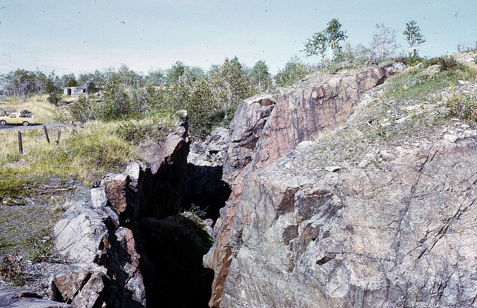
A few interesting, native plants occur on some old silver mining properties located in the town of Cobalt, Ontario. Some of these plants are considered to be calcicolous plants. Several occur at the former Nipissing 404 Mine, located on a hill directly across a lake to the east of the town of Cobalt (Photos 2 and 3). What is a calcicolous plant? Calcicolous plants grow on, and are supported by, a calcium carbonate-rich, calcareous substrate. A calcareous substrate is a difficult place for many plants to grow, but not calcicolous plants. They thrive on it.

Photo 2: View of Nipissing Hill, seen from the town of Cobalt, Ontario, Canada. The exposed hill is the location of several former silver mines, including the Nipissing 404 Mine, and is the location of some calcicolous plants I saw. Photocomposed by Andy Fyon, June 30/18.

Photo 3: Location of the town of Cobalt, Ontario, Canada, the Nipissing 404 Mine area, and the location where I saw calcicolous plants. Satellite image from Google Earth, Nov. 26/22.
The following is a list of calcicolous plants that I have seen growing on, and near, two historic silver mines in the Cobalt area:
Loesel's twayblade (fen orchid) (Liparis loeselii) (Photo 4 and 5)
Kalm's lobelia (Lobelia kalmii) (Photo 6)
yellow lady’s slipper orchid (Cypripedium parviflorum var. makasin) (Photo 7)
variegated scouring-rush (aka variegated horsetail; Equisetum variegatum) (Photo 8 and 9).

Photo 4: Loesel's twayblade (fen orchid) (Liparis loeselii) growing on moist, calcareous soil, Nipissing 404 Mine, Cobalt, Ontario. Photo by Andy Fyon June 24/22

Photo 5: Loesel's twayblade (fen orchid) (Liparis loeselii) growing on moist, calcareous soil, Nipissing 404 Mine, Cobalt, Ontario. Photo by Andy Fyon June 24/22.

Photo 6: Kalm's Lobelia (Lobelia kalmii) growing on moist, calcareous soil, surrounded by Gowganda Formation conglomerate rock, Nipissing 404 Mine, Cobalt, Ontario. Photo by Andy Fyon, Aug. 6/21.

Photo 7: Small yellow lady’s-slipper orchid (Cypripedium parviflorum var. makasin), in an area washed by underground, mine drainage, discharging from an adit at the Little Silver Mine, Cobalt, Ontario. Photo by Andy Fyon, June 30/18.

Photo 8: Variegated scouring-rush (aka variegated horsetail; Equisetum variegatum) growing on a wet, calcareous soil at the foot of the hill where the, below the Nipissing 404 Mine, Cobalt, Ontario. The broken rock is mine waste created by the historic mining. Photo composed by Andy Fyon, June 24/22.

Photo 9: Close up of variegated scouring-rush (aka variegated horsetail; Equisetum variegatum) growing on a wet, calcareous soil at the foot of the hill where the, below the Nipissing 404 Mine, Cobalt, Ontario. Photo composed by Andy Fyon, June 24/22.
The following is a list of the plants that I have seen growing on, and near, the same historic silver mines in the Cobalt area. These plant species tolerate alkaline, calcareous substrates:
Baltic rush (Juncus balticus) (Photo 10 and 11)
Canadian single-spike sedge (Carex scirpoidea var scirpoidea) (Photo 12, 13, and 14)
cotton deergrass (Trichophorum alpinum) (Photo 15)
harebell complex (Complex Campanula rotundifolia) (Photo 16 and 17)
seaside buttercup (Halerpestes cymbalaria) (Photo 18)
shrubby cinquefoil (Dasiphora fruticosa) (Photo 19).

Photo 10: Baltic rush (Juncus balticus) growing on wet, calcareous soil, in a depression within Gowganda Formation conglomerate, Nipissing 404 Mine, Cobalt, Ontario. Photo by Andy Fyon, June 24/22.
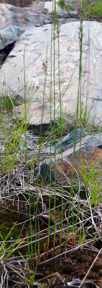
Photo 11: Baltic rush (Juncus balticus) growing on wet, calcareous soil, in a depression within Gowganda Formation conglomerate, Nipissing 404 Mine, Cobalt, Ontario. Canadian single-spike sedge (Carex scirpoidea var scirpoidea) grows in the background. Photo by Andy Fyon, June 24/22.

Photo 12: Canadian single-spike sedge (Carex scirpoidea var scirpoidea) growing on wet, calcareous substrate, Nipissing 404 Mine, Cobalt, Ontario. Photo by Andy Fyon June 24/22.

Photo 13: Canadian single-spike sedge (Carex scirpoidea var scirpoidea) growing on wet, calcareous substrate, Nipissing 404 Mine, Cobalt, Ontario. Photo by Andy Fyon June 24/22.

Photo 14: Canadian single-spike sedge (Carex scirpoidea var scirpoidea) growing on wet, calcareous substrate, Nipissing 404 Mine, Cobalt, Ontario. Photo by Andy Fyon June 24/22.

Photo 15: Cotton deergrass (Trichophorum alpinum) growing on wet, calcareous substrate, Nipissing 404 Mine, Cobalt, Ontario. Photo by Andy Fyon June 24/22.
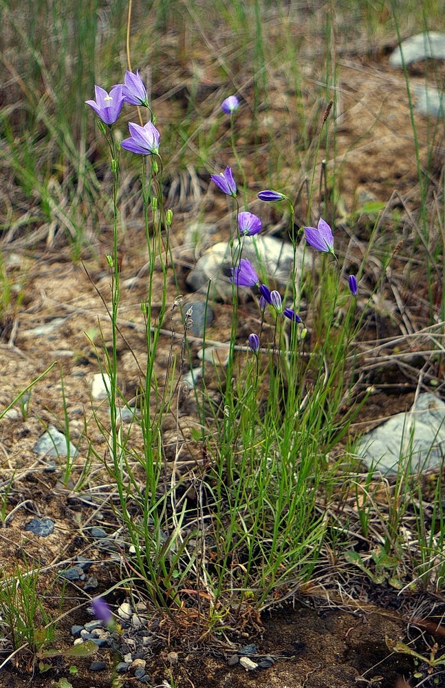
Photo 16 Harebell complex (Complex Campanula rotundifolia), with purple inflorescence, growing on wet, calcareous substrate, Nipissing 404 Mine, Cobalt, Ontario. Photo by Andy Fyon June 24/22.

Photo 17: Harebell complex (Complex Campanula rotundifolia), with white inflorescence, growing on wet, calcareous substrate, Nipissing 404 Mine, Cobalt, Ontario. Photo by Andy Fyon June 24/22.

Photo 18: Seaside buttercup (Halerpestes cymbalaria) growing on wet, calcareous substrate, Nipissing 404 Mine, Cobalt, Ontario. Photo by Andy Fyon June 24/22.

Photo 19: Shrubby cinquefoil (Dasiphora fruticosa) growing on moist, calcareous soil, in a bowl in Gowganda Formation conglomerate, Nipissing 404 Mine, Cobalt, Ontario. Photo by Andy Fyon, Aug. 6/21.
Why do calcareous-tolerant and calcicolous plant species occur on the former Nipissing 404 silver mine property? Is there a source of alkaline drainage that creates calcareous conditions? There are at least two reasons why the presence of these plants is unusual and interesting:
the geology of the immediate area does not consist of calcium carbonate-rich rock, like limestone or dolostone (Photo 21); and
there are acid generating patches located on the old mining property, and acid conditions generally do not support calcicolous plants (Photo 20).
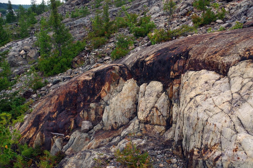
Photo 20: Rusty weathering rock exposed on surface at the Nipissing 404 Mine, Cobalt, Ontario. Geologists call this type of rusty rock a gossan. Gossans form when iron sulphide minerals in the rock react with surface waters to create iron oxide (rust) and acid waters. The original rock was Gowganda Formation conglomerate. The original, unweathered iron sulphide mineral in the rock likely formed at the same time as, and as a result of, the process that formed the silver veins. Photo composed by Andy Fyon, Aug. 6/21.
Geology Of The Nipissing 404 Silver Mine Area:
To gain a better understanding of the geological conditions that might influence the chemistry of the area around the Nipissing 404 silver mine, let’s look at the bedrock geology (Photo 21).
When we talk of a calcareous substrate, most of us envisage a substrate consisting of limestone, dolostone or marl. Limestone is composed of calcite, a calcium carbonate mineral. Dolostone is composed of dolomite, a calcium-magnesium carbonate mineral. Marl is composed of calcite-rich material, including calcite and clay minerals. Yet, when you look at the geology of this former mine area (Photo 21), no limestone or dolostone rocks occur! The rock geology consists of: a) very old (Archean) basalt volcanic rocks (2700 million years old) (Unit A on the bedrock geology map); b) middle aged, Precambrian sedimentary rocks consisting of conglomerate, sandstone, siltstone, and argillite, which geologists call the Gowganda Formation, Cobalt Group, Huronian Supergroup (2,200 to 2,450 million years old); and c) igneous intrusions that are basalt-like in chemical composition, which geologists call the Nipissing mafic sills (2,219 million years old) (Unit C on the geology map). None of these rock are, by themselves, capable of creating a calcareous habitat capable of supporting calcicolous plants.

Photo 21: Very simple bedrock of the Cobalt area. Map unit A: mostly very old (Archean) basalt volcanic rocks (2700 million years old); Map Unit B: middle aged, Precambrian conglomerate, sandstone, siltstone, and argillite rock, which geologists call the Gowganda Formation, Cobalt Group, Huronian Supergroup (2.2 Ga to 2450 million years old); and Map unit C: intrusions that are basalt-like in chemical composition, which geologists call the Nipissing mafic sills (2219 million years old). Geology from OGS Earth (Ontario Geological Survey) superimposed on a satellite base from Google Earth.
Now, limestone and dolostone rocks do occur in the Cobalt region (Photo 22), but those rocks are located a minimum of 5.5 km to the northeast, at a lower elevation, in the Temiskaming Rift Valley. It is unlikely that the surface chemical conditions in the Nipissing 404 mine area, which support the calcicolous plants, were influenced by those limestone and dolomite rocks located to the northeast, in the Temiskaming Rift Valley.

Photo 22: The complex regional geology of the Cobalt area. Map unit A: mostly very old (Archean) basalt volcanic rocks (2700 million years old); Map Unit B: middle aged, Precambrian conglomerate, sandstone, siltstone, and argillite rock, which geologists call the Huronian Supergroup (2.2 Ga to 2450 million years old); Map unit C: intrusive rocks that are basalt-like in chemical composition, which geologists call the Nipissing mafic sills (2219 million years old); Map Unit D: very old (Archean) granite intrusions (about 2700 million years old); Map Unit E: very young (Paleozoic era) shale, limestone, dolostone, and siltstone of the Liskeard Group; and Map Unit F: very young (Paleozoic era) sandstone, shale, dolostone, siltstone. The Temiskaming Rift Valley formed about 155 million years ago when the Earth started to break and spread apart. Geology from OGS Earth (Ontario Geological Survey) superimposed on a satellite base from Google Earth.
Link Between The Silver Mines And Calcicolous Flora:
The silver veins formed long after the rock formed because the veins cut across all the rock types. Could the process that formed the silver veins also have affected the rocks in some way? Perhaps that vein-forming process added calcareous material to the rock? The answer to that question is “yes!”
In addition to the metals silver, nickel, and cobalt, large amounts of the minerals calcite and/or dolomite were also deposited in the veins and adjacent to the veins in the wall rock. These are called secondary hydrothermal minerals: “secondary” because the calcite and dolomite minerals formed after the rock formed and “hydrothermal” because the calcite and dolomite minerals precipitated from the same hot, mineralized fluids, which flowed through fractures in the rock and creates the silver veins. The mineralized hydrothermal fluids carried the silver and other metals, which ultimately become silver veins. The geological process that formed the silver veins also introduced calcite and dolomite into the rock adjacent to the veins. This hydrothermal process transformed the rock adjacent to the veins into a calcareous rock, whose calcium was readily accessible to circulating surface water and groundwater, especially when blasted during the mining sequence into small pieces. You can still find vein material on the rock surface that contains calcite and dolomite.
When exposed to the Earth’s atmosphere, including groundwater, rain, and melting snow, the calcite and dolomite minerals in the waste vein and rock pieces react with the water and weather, leaving calcareous, alkaline bi-products, including calcium- and bicarbonate-rich, alkaline (higher pH) drainage. This chemical reaction is the normal progression of weathering of calcite and dolomite-rich rock and minerals.
Is There Other Evidence Of Calcareous Drainage?:
One of the most distinctive signs that calcareous groundwater drainage occurs on the hill is the presence of white-coloured, calcite precipitates. The calcite mineral precipitates on the Earth’s surface when groundwater that contains a lot of carbon dioxide (CO2), calcium- and bicarbonate-rich components, created by weathering of the calcite bearing altered rock, discharges onto the land surface. At that discharge site, the groundwater loses its dissolved carbon dioxide gas (CO2) by degassing, evaporation, and/or plant and algae photosynthesis. The loss of carbon dioxide gas from the water starts a chemical processes that results in the precipitation of the mineral calcite. This precipitated calcite creates a calcareous habitat. That habitat supports specialized calcicolous plants.
We see calcicolous flora, but do we see evidence of precipitated calcite? Again, the answer is “yes!” That evidence exists in the form of:
calcite crust coating the surface of rocks that sit in wet drainage pathways (Photo 23 and 24)
tiny nodules of the mineral calcite that grow on the rock surface (Photo 25)
white, crusty coating on plants that formed when calcareous drainage evaporated or when plants photosynthesized in calcareous drainage (Photo 26).

Photo 23: Red arrows point to calcite precipitate on the surfaces of cobbles and mine waste rock that sit in a wet, calcareous drainage area, Nipissing 404 silver mine, Cobalt, Ontario. Photo composed by Andy Fyon June 24/22.

Photo 24: The white scale on the surface of this cobble is calcite. The calcite formed when groundwater that was rich in carbon dioxide gas (CO2), calcium, and carbonate components discharged onto the land surface. The discharge caused the loss of the carbon dioxide gas from the groundwater and caused the precipitation of calcite. Photo composed by Andy Fyon at the Nipissing 404 Mine, Cobalt, Ontario, June 24/22.

Photo 25: Calcite nodules formed when groundwater that was rich in carbon dioxide gas (CO2), calcium, and carbonate components discharged onto the land surface. The discharge caused the loss of the carbon dioxide gas from the groundwater and caused the precipitation of calcite as nodules. Photo composed by Andy Fyon at the Nipissing 404 Mine, Cobalt, Ontario, June 24/22.

Photo 26: The white scale present on the tops of moss and soil is calcite. The calcite formed when calcareous drainage evaporated and lost its dissolved carbon dioxide (CO2) gas. That caused calcite to precipitate. Variegated scouring-rush (aka variegated horsetail; Equisetum variegatum) grows in this calcareous substrate. Photo composed at the Nipissing 404 Mine, Cobalt, Ontario. Photo composed by Andy Fyon, June 24/22.
The calcite precipitated after the mining activity began because mining waste rock is coated by white calcite scale.
So, there appears to be compelling evidence that a local calcareous habitat around the Nipissing 404 Mine, and elsewhere in the Cobalt area, was created by recent weathering of secondary, hydrothermal calcite and dolomite minerals contained in mine waste rock and veins that are exposed to the atmosphere as a result of the historic silver mining activity. The weathering created alkaline, calcareous drainage from which the calcite precipitated as nodules, coatings on waste mine rock, and as a white-coloured, crusty coating on plants and soil.
Summary:
A local calcareous habitat was created around some historic silver mines in the Cobalt area. The calcareous habitat formed by weathering of hydrothermal calcite and dolomite minerals. The calcite and dolomite formed in veins and the adjacent rock during the geological process that created the silver veins. Surface weathering of calcareous waste mine rock and groundwater reaction with secondary hydrothermal calcite and dolomite that remain underground in the mine area created carbon dioxide-rich, alkaline, calcareous drainage. Where the calcareous drainage lost its carbon dioxide gas, due to degassing, evaporation, and/or plant photosynthesis, calcite precipitated. That recent calcite precipitate occurs as a scale coating and as nodules, which together with the calcareous drainage, create an anthropogenic calcareous habitat that supports calcicolous- and calcareous-tolerant plants.
What about the fox that was the target of Fred LaRose’s hammer (Photo 27)? Well, I suspect it lived a full life, supplemented by food supplied by the prospectors who flooded into the area at the time of the silver discovery.

Photo 27: Perhaps one of the distant relatives of the fox that was rumored to indirectly caused the prospecting rush to the area now occupied by the town of Cobalt, Ontario, Canada. Photo composed by Andy Fyon, July 23/14.
Citizen Science:
There is an excellent road tour of the historic mines in the Cobalt area called the Heritage Silver Trail. If you visit any of the old historic mine sites in the Cobalt area, watch where you walk, and look for patches of white-coloured calcite precipitate. The precipitate may occur as tiny (mm-size) nodules or calcite scale on the waste rock or soils. This calcite and associated surface water creates a calcareous habitat. If you find any calcite precipitate, note any plant species that grow near, and on, the calcareous habitats. Do you see any of the plant species I illustrate in this note? Do you see any of the plant species I illustrate well away (kilometers) from the mining activity? Take a photo - a good focused photo. Let me know what you find.
February 25/22; Dec. 10/22