
Western Canada Badlands: Where Geology, Life, Culture and Heritage Meet
Canada is remarkable for our diverse and dramatic landscapes. This includes the badlands of western Canada, which generally occur on the Great Plains of Alberta, Saskatchewan and Manitoba. Given their descriptive name, you might envision them to be gnarly lands. Yet, I find the badlands to be highly unusual and special. They are amazing places to hike, to experience geological landforms that evoke strong emotions and to become acquainted with specialized plant species and unusual animals.
This note focuses on some of the badlands in Canada’s prairie provinces. I explain what the badlands are, how they formed and how they got their name. I describe some of their physical characteristics and a few of their heritage and cultural influences.
Land Acknowledgment
I acknowledge that the badlands I have visited over the last 15 years occur in the homelands of the Metis and several First Nations and peoples, including the Blackfoot, the Tsuutʼina, the Assiniboine and the Gros Ventre nations. I recognize and thank the First Nations and Metis people as stewards of this land. Acknowledgement of these peoples and their land stewardship reminds us all to reflect on and respect their unique relationship to this land. My acknowledgment is also an invitation for all of us to identify and engage in actions that respect and reinforce Canada’s commitments made in the treaties, pursue the recommendations of the Truth and Reconciliation Commission reports and respect Indigenous rights. Remember that all settlers are Treaty people. Miigwetch - thank you.
Disclaimer
I am a geologist. I see the world through “geological eyes.” I have not formally mapped or studied the badlands, but I have visited many. For this note, I share some of my observations, but I rely on the research of others. I make generalizations to help provide information to a non-geological audience. I understand that generalizations may be inappropriate, incorrect and even misleading, so please consider this note to be my subjective musings, supported by observations, but definitely not of research quality.
Rock Age Notation Convention
When geologists refer to rocks whose age is constrained by a time span, we use a convention that puts the oldest date first, followed by the younger date (e.g., 80 to 70 million years ago). That sequence mirrors the order in which rock layers formed. Specifically, the oldest rock formed first, so the old date appears first in the list.
What Are Badlands?
Badlands consist of deep canyons (Photo 1), ravines and gullies, buttes (Photo 2) or islands of rock that stand erect from the canyon floor and hoodoos (Photo 3).
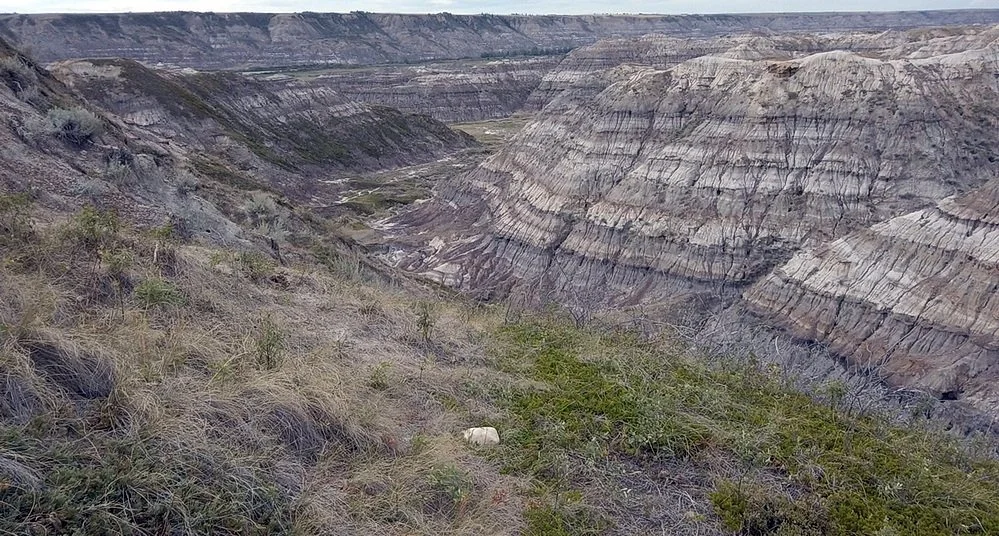
Photo 1: The coloured sedimentary rocks of the Horsethief Canyon, near Drumheller, Alberta, Canada, illustrate the dramatic badland landscape. Image by Andy Fyon, August 11, 2023.

Photo 2: The Castle Butte geological feature located in the Big Muddy badlands, southern Saskatchewan, Canada. Photo by Andy Fyon, June 14, 2012.
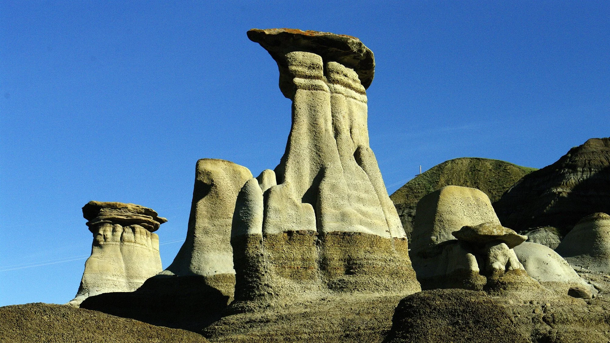
Photo 3: Hoodoo geological features at Willow Creek area, southeast of Drumheller, Alberta, Canada. Image by Andy Fyon, June 22, 2014.
How did badland canyons form?
During the last ice age, which peaked about 23,000 years ago, several ice sheets covered almost all of Canada. As those ice sheets melted in western Canada, torrential meltwater rivers were created. Those rivers tore through the weak, soft, sedimentary rocks exposed on the land surface. They created deep, wide canyons between about 17,000 and 13,000 years ago. Those canyons became the badlands. By deep, I mean stunningly deep, especially when contrasted against the relatively flat prairie. For example, the badland canyons which comprise the Red Deer River valley, near Drumheller, Alberta, are up to 200 metres (655 feet) deep.
The soft canyon walls continue to erode today. Downpours of rain from prairie thunderstorms create geological features called rills (Photo 4). Rills are mini-gullies carved into cliff walls. Modern erosion removes soft badland rock at the amazing rate of 1–2 cm per year. That is very fast from a geological perspective since it can take millions of years to erode mountains.
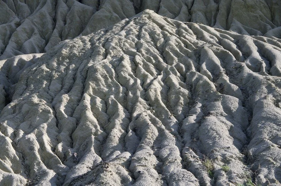
Photo 4: Erosion rills, or mini-gullies, are common in badland canyons and are created by runoff from modern-day prairie thunderstorms. Location: Castle Butte, Saskatchewan, Canada. Image by Andy Fyon, June 14, 2012.
Underfit or misfit rivers
The volume of post-glacial meltwater responsible for carving the badland canyons was much greater than the volume of modern rivers that occupy the canyon floors. For example, the width of the Horsethief Canyon is 3 km (2 mi) whereas the width of the present-day Red Deer River, located on the canyon floor, is only about 0.2 km (0.1 mi) (Photo 5). Geologists call the Red Deer River an underfit or misfit river, because, given its present size, it is incapable of carving out the canyon it occupies, even at its modern-day, maximum flood stage.

Photo 5: The Horsethief Canyon badland near Drumheller, Alberta, Canada, was carved out by torrential meltwater river flow at the end of the most recent ice age, about 17,000 years ago. The canyon width is about 3 km (2 mi), whereas the width of the present-day Red River is only about 0.2 km (0.1 mi). The modern Red Deer River is called an underfit or misfit river because it does not carry enough water to carve out the Horsethief Canyon. Image: Google Earth.
Why do the canyon walls have different coloured layers?
The white, brown, and black layers seen in the canyon walls are another distinctive badlands feature (Photo 1). Many badland wall rocks formed about 75 million years ago during a time geologists call the Late Cretaceous period. These coloured layers are beds of sedimentary and volcanic rock. Millions of years ago, the sedimentary beds were deposited by ancient rivers along the edge and on the bottom of an inland sea called the Western Interior Seaway. This seaway stretched north to south from the Gulf of Mexico to the Arctic Ocean, dividing North America into a western and an eastern part. The warm, shallow sea covered most of the modern Great Plains. Some of the horizontal beds represent deposits that accumulated from ash that erupted from volcanoes in the region. Each bed of badland rock represents a different slice of geologic time. The oldest bed lies at the bottom of the canyon. Successively younger sediments lie on top of each other. The youngest layer sits at the top of the canyon – at least for the canyon wall that you face.
When we call something a rock, we think the material is physically hard. But, in the case of the badland rocks, most of the sedimentary beds are relatively soft. You can scratch most of them with your fingernail. They consist of beds of sandstones, siltstones, mudstones, volcanic ash and black organic material called coal. That is why they were easily eroded by wind and water to create the badlands. Furthermore, different types of badland rock erode at different rates, which creates many of the badland geological features.
All of these rock types are composed of different minerals, which impart a different colour to each rock type (Photo 6): red-brown for iron-rich sediments; black for coal beds; and white and brown for clay-rich sediments.

Photo 6: When standing on the ground, we don’t see and don’t appreciate the many layers of rock that lie hidden beneath our feet. It is not until we see the badland canyon walls that we appreciate the complex variety of different rock types that lie hidden beneath our feet. Location: Dinosaur Provincial Park, Alberta, Canada. Image by Andy Fyon, August 10, 2019.
Badland Rocks
Armed with the clues that come from the different colours of rock types seen on the canyon walls, let’s dig a little deeper into the varied rock types.
Mudstone, claystone and volcanic ash
Brown mudstone sedimentary rock formed from at least two sources: a) fine-grained material eroded from other rocks in the area; and b) volcanic deposits called ash, which were blown out of volcanoes in the region. Mudstone formed when fine-grained particles were deposited by ancient, slow-moving rivers along a river bottom and on the bottom of the ancient inland sea millions of years ago. Unlike the mudstone sediments, volcanic ash was blown out of volcanoes about 82 to 73 million years ago, fell from the sky like dark snow and blanketed the land surface. The presence of multiple volcanic ash beds tells us there were several distinct volcanic eruptions. Much of the volcanic ash now consists of bentonite, a type of clay. Some people call this type of rock a bentonite claystone or gumbo rock. Geologists use chemical fingerprints to trace ash deposits back to their source volcanoes. Using this technique, geologists proved that one volcanic ash deposit, named the Judith River Formation bentonite (or the Plateau Tuff), located in Dinosaur Provincial Park, was likely erupted from a volcano in the Elkhorn Mountains Volcanics complex of southwestern Montana.
But, why is there so much bentonite clay in these rocks? Beneath the Earth’s surface, a process called diagenesis transforms unconsolidated sediments into rock. Diagenesis generally changes primary minerals into secondary minerals. In the case of the badlands, that transformation started shortly after the sediments and volcanic ash were deposited on the land surface and continued as the sediments were buried and heated by deposition of successive beds of overlying younger material. During diagenesis, the primary volcanic ash underwent physical and chemical changes to produce secondary bentonite clay.
Chemical weathering is another process that creates bentonite clay minerals. Rocks are made of primary minerals. Primary minerals formed at the same time that the original rock formed. Many primary minerals are not stable on, or near, the Earth’s surface because they react with the Earth’s atmosphere, surface water and groundwater. That chemical reaction, also called chemical weathering, breaks down the primary rocks and minerals into their constituent parts.
When seen in the field, the bentonite clay has a distinctive popcorn texture created by the wetting and the drying of the clay (Photos 7 and 8).

Photo 7: The popcorn surface texture of clay-rich mudstone or volcanic ash is a warning to avoid this material when wet. It can get really slippery! Location: Dinosaur Provincial Park, Alberta, Canada. Image by Andy Fyon, August 8, 2019.
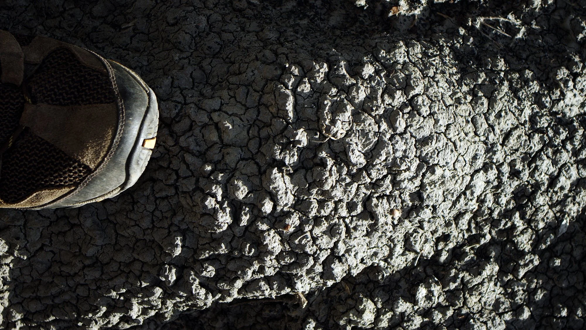
Photo 8: A close-up image of the popcorn surface texture of clay-rich mudstone or volcanic ash rock types. Location: The badlands near Rosedeer, Alberta, Canada. Image by Andy Fyon, August 11, 2023.
When wet, this bentonite-rich clay becomes very slippery, clings to your boots (Photo 9) and creates hazardous but amusing hiking conditions causing you to “ski” down steep badland slopes after a summer rain!

Photo 9: Wet clay can create hazardous hiking conditions because the very slippery clay clings to boots. Image by Andy Fyon, September 21, 2022.
To summarize, the sediments we call mudstone, volcanic ash and claystone underwent changes several times over geological time, namely: a) weathering shortly after deposition on the land surface about 75 million years ago; b) burial and diagenesis, which transformed the primary sediments into rocks over millions of years; and c) periodic modern chemical weathering of rock exposed on the land surface. It is complicated! For those reasons, most of the rock-forming minerals we see today in badland volcanic ash deposits contain a lot of secondary bentonite clay.
Coal
Black coal deposits (Photo 10) represent ancient swamps where dead plant material accumulated on the surface of the ancient landscape. Over millions of years, the dead plant material was buried, compressed and heated as successive layers of overlying sediments accumulated. Those processes transformed the dead plant material into coal. In some badlands, several beds of coal are visible on the valley wall (Photo 11). In the Red Deer River valley, some of these coal beds were mined in the late 1800s (Photo 11).
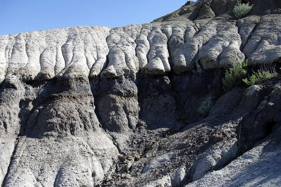
Photo 10: A black bed of coal lies between two white sandstone beds. Location: Star Coal Mine, near Rosedale, Alberta, Canada. Image by Andy Fyon, June 22, 2014.

Photo 11: In some badlands, multiple layers of black coal beds occur. I am standing at the top of a badland butte located near the historic Star Coal Mine, near Rosedale, Alberta, Canada. Image by Elizabeth Fyon, June 22, 2014.
Sandstone
Many badlands display beds of white- or light-coloured sedimentary rock called sandstone (Photo 12). I find it difficult to distinguish sandstone from mudstone, especially if I observe them from a great distance.

Photo 12: Light-coloured sandstone showing ghost-like or wispy inclined bedding is called cross-bedding. Location: Castle Butte, Big Muddy badland, Saskatchewan, Canada. Image by Andy Fyon, June 14, 2012.
To help identify sandstone, I look for the presence of thin, inclined beds that truncate each other at an angle (Photo 13). Sometimes these inclined beds are ghost-like and hard to see (Photo 13, left image).
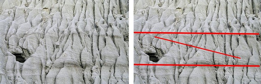
Photo 13: The left and right images show the same sandstone rock. On the right, I have drawn red lines to highlight the traces of the horizontal and inclined cross-bedding to make it easier to see the cross-bedding. Erosion rills, marked by the vertical mini-gullies, cut down through the face of the exposure. Location: Castle Butte, Big Muddy badlands, Saskatchewan, Canada. Image by Andy Fyon, June 14, 2012.
Other times, the inclined beds are easy to see, especially where they are stained brown, indicating the presence of weathered iron minerals (Photo 14).

Photo 14: Cross-bedding developed in sandstone. The material is brown, which indicates the presence of a weathered, rusty, iron oxide mineral. Location: Castle Butte, Big Muddy badlands, Saskatchewan, Canada. Image by Andy Fyon, June 14, 2012.
Geologists call the inclined beds cross-bedding or cross-stratification. Wind or water currents can create cross-bedding given the right flow conditions and the right sedimentary material. The cross-bedded sandstones in my images were formed in ancient river channels by deposition of sediments from fast-flowing rivers millions of years ago.
Ironstone
The red- to rusty-brown rock in the badlands is called ironstone. Ironstone formed when iron-rich groundwater seeped through and transformed soft beds of rock into hard iron-rich rock (Photo 15).

Photo 15: Ironstone gets its orange-brown colour from the chemical weathering and rusting of iron minerals in rocks inter-layered with sandstone and mudstone. When soft sandstone and mudstone beds erode away, ironstone layers break up into pieces and accumulate at the base of hills. The ironstone layers and fragments give the badland landscape its distinctive rusty colour. Location: The badlands in Dinosaur Provincial Park, Alberta, Canada. Image by Andy Fyon, August 8, 2019.
Often, when the enclosing, softer sedimentary rock has eroded away, broken fragments of ironstone accumulate on the ground at the base of a slope (Photo 16).

Photo 16: Pieces of broken ironstone that have accumulated beneath a layer of ironstone. Location: Horsethief Canyon badland, Drumheller, Alberta, Canada. Image by Andy Fyon, Aug. 11, 2023.
Badlands: Where Nature, Heritage and Culture Meet
The dramatic landscapes of badlands have influenced our culture and heritage.
Origin of the name
The name badland is attributed to the Lakota First Nations people of southwestern North America, who describe this landscape as makošiča, meaning “bad lands”. Some linguists speculate that the Assiniboine (Nakoda) First Nations, whose homelands lie in the northern Great Plains and who were friends with the Lakota, may also have used the word makošiča to describe these daunting landscapes. However, I cannot confirm that in the published literature. Given the challenging, rugged landscape, the extreme temperatures and scarce water, it is not surprising that such an evocative name would evolve in local Indigenous languages.
Other First Nations do not appear to have a general name for badlands. Rather, they emphasize the cultural and spiritual value of a specific area. For example, the Blackfoot First Nations use the term Áísínai’pi, meaning "it is pictured" or "writing-on-stone", to refer to the badlands around Writing-on-Stone Provincial Park, a UNESCO World Heritage site in Alberta, Canada, because numerous petroglyphs and pictographs occur here.
More recently, when French voyageurs struggled to cross the badlands, they called them "les mauvaises terres à traversé" meaning "bad lands to travel through”.
Badlands dinosaurs and fossils
A fossil is any preserved remains, impression or trace of a once-living thing from a past geological age. One exciting example is a dinosaur fossil (Photo 17).

Photo 17: Fossil remains of a Corythosaurus dinosaur on display in Dinosaur Provincial Park, Alberta, Canada. Image by Andy Fyon, August 9, 2019.
Other fossil examples include shells, skeletons and imprints of animal tracks preserved in stone (Photo 18). In this regard, the badlands of Alberta, Saskatchewan and Manitoba are world famous for their dinosaur fossils. Erosion of the badlands exposes and ultimately releases the ancient fossils, making them easier for researchers to find and collect for study.

Photo 18: One of many dinosaur tracks preserved along Flatbed Creek, Tumbler Ridge, British Columbia, Canada. The three-toed fossil print was left by a theropod dinosaur that walked over a mudflat about 100 million to 94 million years ago. Location: Cabin Pool, Flatbed Creek, Tumbler Ridge, British Columbia, Canada. Image by Andy Fyon, July 9, 2013
Most of the dinosaur fossils recovered from the Alberta badlands come from a rock unit that geologists call the Dinosaur Park Formation. Volcanic ash deposits in the Dinosaur Park Formation are about 77 to 74 million years old! Knowing the age of a rock tells us how quickly the sediments and volcanic ash accumulated and helps geologists reconstruct the ecological changes that took place while the dinosaurs roamed the land.
The Royal Tyrrell Museum (Photo 19), near Drumheller, Alberta, is one destination visited by people from around the world who want to see these famous dinosaur fossil displays. Remember: in the Canadian provinces of Alberta, Saskatchewan and Manitoba it is illegal to collect fossils.

Photo 19: My grandson (the person in the black shirt and shorts) standing in front of the world famous Royal Tyrrell Museum, located near Drumheller, Alberta, Canada. Image: Andy Fyon August 10, 2023.
Stargazing
Most of the western Canadian badlands are not officially designated by the Royal Astronomical Society of Canada (RASC) as a dark sky preserve; however, their skies are dark and provide excellent stargazing opportunities. The one area of badlands that is designated by the RASC as a dark sky preserve occurs in Grasslands National Park, southwestern Saskatchewan (Photo 20), but that designation applies to the entire national park, not just the badlands. It is considered to be one of Canada’s darkest dark sky preserves!
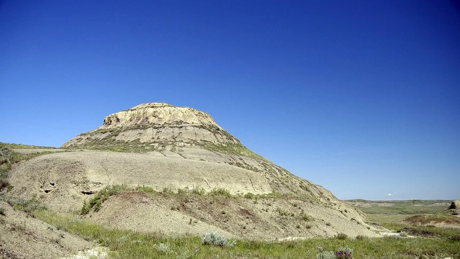
Photo 20: Fabulous big sky and a badland butte in the east block of Grasslands National Park, Saskatchewan, Canada. Image by Andy Fyon, June 12, 2012.
Resiliant animals
The western Canadian badlands are home to a range of animals that live in the hot, dry conditions. Grasslands in and adjacent to the badlands support the reintroduced plains bison (Bison bison bison), the reintroduced black-footed ferret (Mustela nigripes), mule deer (Odocoileus hemionus) (Photo 21) and pronghorn (Antilocapra americana) (Photo 22). Some of these animals are not restricted to the badlands, but live in the surrounding grasslands and forested areas. They are all able to endure the bitterly cold winters and very hot summers.
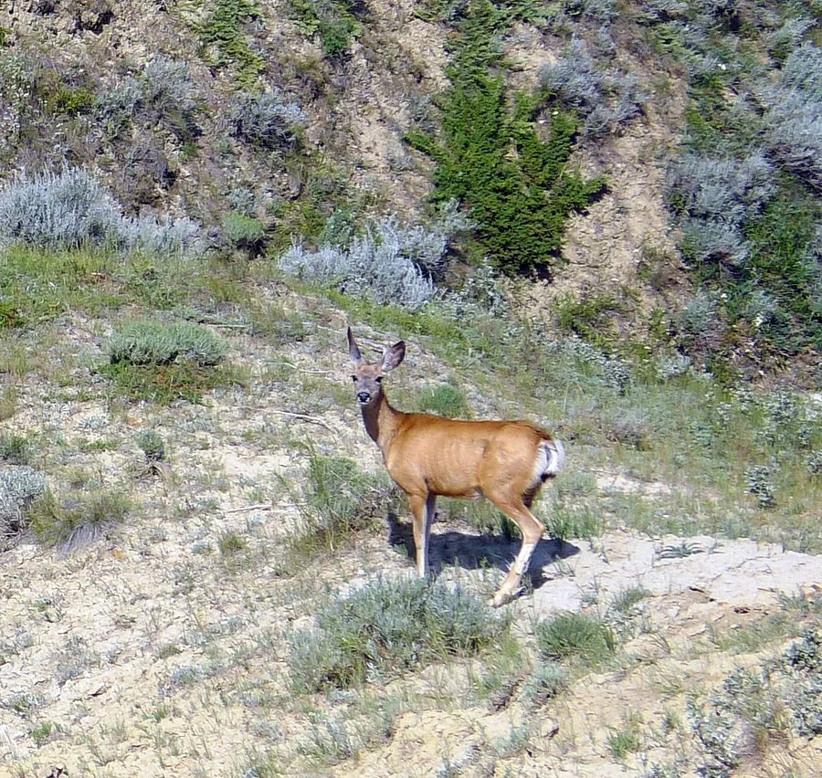
Photo 21: A mule deer (Odocoileus hemionus) on the edges of a badland near Eastend, Saskatchewan, Canada. Image by Andy Fyon, July 26, 2011.
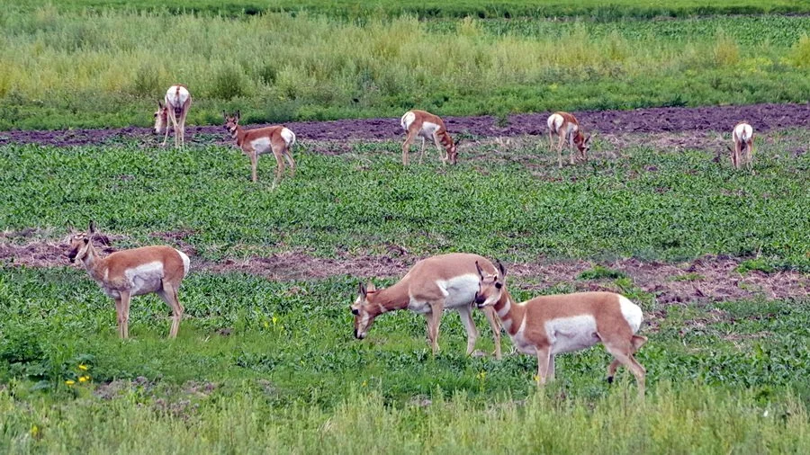
Photo 22: A small herd of pronghorn (Antilocapra americana) feeding in a fallow field northwest of Leader, Saskatchewan, Canada. Image by Andy Fyon, August 10, 2019.
Badlands are also home to the northern scorpion (Paruroctonus boreus), western black widow spider (Latrodectus hesperus) and prairie rattlesnake (Crotalus viridis), none of which I’ve had the thrill to meet along a trail! I have seen a bullsnake (Pituophis catenifer sayi) in the badlands from a distance (Photo 23). I confess it held my full attention because I thought it was a prairie rattlesnake!

Photo 23: A bullsnake (Pituophis catenifer ssp. sayi) that was sunning itself on top of a wood beam that secured the entrance to a badland cave, near Coronach, Saskatchewan, Canada. Image by Andy Fyon, June 13, 2012.
Badlands and birds
Notable badlands, like those along the Red Deer River near Drumheller, Alberta, are prime destinations for birdwatchers. This river valley is a transition between different environments, which attracts a variety of birds, many of which are described by experts. The Red Deer River valley and associated badlands is also a flyway for migrating raptors in the fall.
Alkali lakes occur in the valleys of some badlands, like the Big Muddy in Saskatchewan; they too are important habitats for resident and migratory birds. One reason the birds are attracted to the alkali lakes is the abundance of brine shrimp that breed in the alkali waters. The area around Chaplin, Saskatchewan, is renowned for its access to popular alkali lakes that support a vibrant shorebird population (Photo 24).

Photo 24: Two American avocets (Recurvirostra americana) feed on brine shrimp and small aquatic animals in an alkali lake. Location: Chaplin Lake, near Chaplin, Saskatchewan, Canada. Image by Andy Fyon, July 27, 2011.
Badlands and bad guys
Western Canada's badlands are not just distinctive landscapes beneath dark skies. They also hide a dark historical past. Some of the southern badlands were known to be part of the outlaw trail, which ran from the Big Muddy badlands, in southern Saskatchewan, through the United Stated into Mexico. In the 1800s and early 1900s, outlaws like Kid Curry, Butch Cassidy, Dutch Henry, the Sundance Kid and Sam Kelly and his Nelson-Jones Gang used the badlands to avoid the long arm of the law. Regardless of whether an outlaw robbed banks, stole property from passengers on trains or wagons, or stole cattle or horses, they used the natural buttes as look-out points and the caves (Photo 25) and gullies as safe havens in which to hide. The badlands are not just examples of natural beauty; they contribute to the heritage of the local areas.
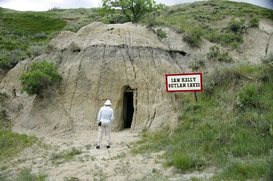
Photo 25: Outlaws carved out or enhanced existing caves in the badlands to hide from the law in the 1800s and early 1900s. Location: Sam Kelly outlaw caves, in the Big Muddy badlands near Coronach, Saskatchewan. Image by Andy Fyon, June 13, 2012
Badlands and specialized plants
Given the harsh badlands conditions, you might think that using the words “badlands” and “plants” in the same sentence is an oxymoron. This is far from the reality. Native plants do grow in the badlands, but they have special adaptations that enable them to survive in the harsh conditions, including the ability to conserve water, to tolerate intense solar radiation and to anchor themselves in the easily eroded soils. One example is the tufted evening-primrose (Oenothera cespitosa ssp. cespitosa) sometimes called gumbo primrose (Photo 26). It has a thick, woody taproot that helps anchor the plant to eroding slopes. Its extensive root system accesses soil moisture deep below the land surface. It avoids the drying daytime sun by blooming at dusk and overnight to conserve water. It has a low-growing, tufted form to minimize exposure to drying winds. Its grey-green foliage, which is covered by fine hairs, helps reflect sunlight and deflect drying winds. It has the ability to go dormant during the hottest and driest summer periods. Wow! Adaptation at it best!
In a separate companion note (under development as of February 6, 2026), I describe more completely some of the native badland plant species and their adaptations.

Photo 26: Tufted evening-primrose (Oenothera cespitosa ssp. cespitosa) growing on the Avonlea badlands, Saskatchewan, Canada. Image by Andy Fyon, June 11, 2012.
First Nations reverence for the land and its plants and animals
It is not surprising the First Nations people left sacred petroglyphs (images scratched into rock), pictographs (images painted on rock) and images of animals created by arranging rocks into patterns on the ground to show their respect for the land, its plants and its animals. The petroglyphs and pictographs in the badlands of Writing-on-Stone Provincial Park, Alberta, are an excellent example. Rocks arranged by First Nations people in the Big Muddy badlands in Saskatchewan represent important ceremonial and animal symbols. In St Victor Petroglyphs Provincial Park, near St Victor, Saskatchewan, about 300 petroglyph images were carved by First Nations people on a cliff and its sandstone cap rock above the cliff (Photo 27).

Photo 27: One example of the First Nations petroglyphs accompanied by a sign that illustrates and explains the symbols. Location: St Victor Petroglyphs Provincial Park, near St Victor, Saskatchewan. Image on the left composed by Andy Fyon, June 12, 2012.
The St Victor petroglyphs are estimated to have been carved between 500 and 1700 years ago, but the identity of the carvers and the exact time when they were made remain a mystery.
From a geological perspective, the aforementioned badlands rocks used by First Nations peoples formed 75 to 60 million years ago. Regarding the creation of the actual badlands canyons and features, details of each site may differ, but the general geological processes are common to all. The cliffs, valleys and canyons formed between 17,000 and 13,000 years ago when meltwater rivers, created by a melting ice sheet at the end of the last ice age, carved away the soft rock to create the badlands, complete with vistas and sacred locations selected by the First Nations people to carefully leave their symbols (Photo 28).

Photo 28: The vista and sacred site at the cliff top in St Victor Petroglyphs Provincial Park, overlooking the valley carved out by a meltwater river at the end of the last ice age. Location: St Victor Petroglyphs Provincial Historic, south of St Victor, Saskatchewan. Image by Andy Fyon, June 12, 2012.
Summary: Beautiful Badland
The badlands of western Canada are beautiful. Their environment is harsh. The winds are persistent. The land is very hot and dry in summer and cold in winter. Only specially adapted animals and plants survive. The badlands geologic history began about 75 million years ago with the birth of the sediments and volcanic ash, both of which were converted to rock. After the ice age, about 17,000 years ago, the rocks were scoured by powerful meltwater rivers to create canyons, valleys, gullies and buttes. Exposed rock was weathered by wind and water and transformed into shapes resembling human spirits (Photo 29).

Photo 29: A hoodoo that assumed the form of a woman reflecting in peace about the world around her. Location: badlands of Dinosaur Provincial Park, Alberta, Canada. Image by Andy Fyon, August 8, 2019.
First Nations people revered the badlands and its animals. European settlers were thwarted when they tried to cross them with their wagons. Outlaws hid in them. Early farmers learned to avoid them. Yet, the badlands are a unique ecological niche.
The badlands are amazing landscapes to see and hike through. If you hike them in the summer, bring lots of water and wear a hat. If you are lucky, you might see a prairie rattlesnake, a northern scorpion or even a black widow spider (Photo 30)!

Photo 30: Although the badlands are really interesting places to visit, be aware that they are home to other animals, some of which should keep you alert to where you walk and especially where you place your hands. Location: Dinosaur Provincial Park, Alberta, Canada. Image by Andy Fyon, August 8, 2019.
Andy Fyon, February 6, 2026.